Local History
Corsenside (Northumberland)

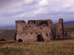
Ridsdale Ironworks, Corsenside. Photo by Northumberland County Council, 1995.

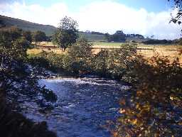
View over the River Rede north of West Woodburn. Photo by Harry Rowland.
The parish of Corsenside lies in central Northumberland. It is mainly high open moorland, with the commons of Corsenside, East Woodburn and Chesterhope encircling the settlements of East and West Woodburn. Through the middle of the parish runs the River Rede, on its way southwards to join the North Tyne near Bellingham. There is now no village of Corsenside, just a farmstead and a medieval church, with the main settlement of the parish now at West Woodburn. The name Corsenside is thought to derive from the Gaelic name 'Crossan.' The upland areas are rich in upstanding remains of all periods, from the Bronze Age to the 19th century.
Although there may have been earlier inhabitants, the first evidence we have for human activity belongs to the Neolithic. This comes from two polished stone axe heads found at West Woodburn. Remains of any Neolithic settlement have not yet been discovered in the parish and may have been destroyed long ago by later agricultural and industrial activity in the area. With the arrival of the Bronze Age we get our first evidence of prehistoric burial practices with several burial cairns known, for example at Bell Knowe. Unusually, another example is said to have contained gold beads when it was excavated in the 19th century but the site has now been quarried away. As well as their burial monuments, Bronze Age people have also left traces of their fields. There are several areas where fields of cord rig have been discovered, as well as a more extensive field system at Darney Crag. Here, clearance cairns, field banks and burial cairns have been found but so far we are not so sure of where these people lived. A possible example may lie nearby at Staniel Heugh where a round house was discovered together with another prehistoric field system of cairns and cord rig.
There is a gap in our knowledge for the Iron Age in Corsenside and it is not until the Roman period that we begin to get clear evidence of settlement in the parish. As well as a Romano-British farmstead the most visible remains are those of the garrison fort of Habitancum. It lies next to the route of a Roman road called Dere Street which has at least one milestone and temporary camp lying alongside it as well as the site of a bridge across the River Rede. A large number of Roman altars, gravestones and other carved stones have been discovered around Habitancum, many are built into nearby farm buildings. One of the most unusual is Robin of Risingham, a figure of a native hunting god, which is the only known Roman statue in Northumberland carved from a rock outcrop.
As in many parts of Northumberland there are no monuments or finds from the early medieval period. It is only after the Norman Conquest that we can once again recognise remains of the past in the parish. A number of medieval villages and hamlets have been identified in the parish, but only a few have any supporting documentary evidence or visible remains. The medieval grange of Hallyards, the family seat of the De Lisle family, stood at East Woodburn. All that can be recognised today are its fishponds. The medieval parish church, dedicated to St Cuthbert, stands at Corsenside and dates to the 12th century.
The medieval and post-medieval periods were troubled times in the Border regions of England and Scotland, with countless cross-border skirmishes and raids. This is amply illustrated by the number of bastles in the parish with examples at The Heads, Harewalls, Townfoot Farm, Coldtown, Brig, Cherry Trees, Low Leam and Low Cleughs. As the border region became more peaceful in the 17th and 18th centuries some of the bastles were adapted into farm buildings or farmhouses, but others lie as ruins on the hillsides.
Apart from agriculture, evidence of other economic activities in the post-medieval period include, lime kilns, quarries, coal workings and the Ridsdale Ironworks. The ironworks were a short-lived venture in the 19th century but failed to thrive in such a remote situation, despite having supplied the pig-iron used in construction of the High Level Bridge in Newcastle upon Tyne. The Border Counties Railway arrived too late to revive its fortunes. Today the parish lies on one of the main border road routes into Scotland, much of which follows the same line as Dere Street Roman road.
N13013
UNCERTAIN
Disclaimer -
Please note that this information has been compiled from a number of different sources. Durham County Council and Northumberland County Council can accept no responsibility for any inaccuracy contained therein. If you wish to use/copy any of the images, please ensure that you read the Copyright information provided.