Local History
Blanchland (Northumberland)

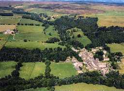
Blanchland. Photo by Air Images Ltd, 2003.

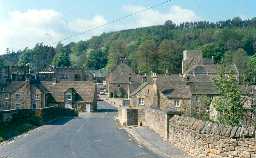
View of Blanchland village from the south. Photo by Northumberland County Council.
Blanchland parish lies in south Northumberland, deep in the North Pennines Area of Outstanding Natural Beauty, on the boundary with County Durham. The landscape is quite varied with the wooded valley of the River Derwent in the south rising northward to high moorland on Blanchland Moor.
Evidence from early prehistoric times is scarce with a Mesolithic flint scatter found on Birkside Fell and a Neolithic arrowhead from War Law the only finds.
The earliest settlement in the parish is a Bronze Age hut circle settlement on Burntshield Haugh. Here, there is a cluster of later prehistoric farmsteads, probably dating into the Roman period. A Bronze Age burial place has also been discovered on Birkside Fell overlooking these settlements. A ring cairn was excavated in the 1990s and a spectacular burial urn unearthed that contained the cremated remains of at least two individuals.
In the Iron Age and Roman periods the land at Burntshield Haugh must have remained an attractive place for people to live and farm. Small farmsteads on Burntshieldhaugh Fell, east of Burntshield Haugh and north-east of Burntshieldhaugh Fell are surrounded by field systems of enclosures, low field banks and a cairnfield.
The main settlement in the parish is the pretty village of Blanchland whose origins lie in Blanchland Abbey, founded in the 12th century by monks of the Premonstratensian order. They typically settled wild places and developed granges and estates around them so as to be self-supporting. This was successful at Blanchland where many of the buildings from that period have been re-used in later times. The Lord Crewe Arms was once the abbey guest house and many of the buildings around The Square incorporate medieval masonry, for example No 1 The Square and The Angel. Fishponds would have provided a fresh supply of fish. Entrance to the abbey precincts was through a gatehouse, a visible reminder that Scottish raiding took place in both Northumberland and Durham. Indeed, Newbiggin medieval village was raided in the 14th century. Inside the Church of St Mary are some fine medieval grave slabs of the abbot and his forester, as well as rare medieval stained glass. A medieval road linked Blanchland and Hexham to the north. Coal mining seems to have developed early in this part of the county and traces of a bellpit lie near the Shildon Burn.
Industry really took off in the post-medieval period when leadmining developed.
The North Pennines is well known for its lead mining industry. Galena was mined via adits and levels running from the Derwent valley and its tributaries where the ore veins were exposed. Sometimes veins were exposed by hushes such as the one on Burntshieldhaugh Fell; a common practice in the 18th and 19th centuries. Several lead mines and ore works operated in the parish, including Beldon, Birkside and Shildon. Preliminary separation of Galena from associated rocks was made creating spoil heaps from the waste. Smelting was carried out elsewhere, although slag has been found at the isolated High Actonmill. Removal of water from the mines was carried out by some of the earliest engine houses in the North, such as that at Shildon.
Ore was carried by [pack horses] as well as supplies to the mines. There are network of paths that have their origins in this and the medieval period to the `hub of the wheel' at Blanchland. An appropriately named example is the Carrier's Way. John Wesley preached at Blanchland in the 18th century and noted that the village was little more than ruins. Farming was often carried out in conjunction with lead mining. To improve the soil, farmers built lime kilns to make quicklime to spread on the fields and many can still be seen in varying degrees of survival across the parish, such as Newbiggin and Park House Fell. However, with the collapse of lead mining the parish now a haven of peace and quiet ' something that the medieval monks would have sought. Little modern building has taken place but what there has, such as Blanchland vicarage, has in time-honoured Blanchland fashion re-used earlier remains.
N12996
UNCERTAIN
Disclaimer -
Please note that this information has been compiled from a number of different sources. Durham County Council and Northumberland County Council can accept no responsibility for any inaccuracy contained therein. If you wish to use/copy any of the images, please ensure that you read the Copyright information provided.