Local History
Horncliffe (Northumberland)
Horncliffe parish lies on the south bank of the River Tweed in north Northumberland.
The earliest remains in the parish are Bronze Age. Two barrows lie on the high land west of Norham West Mains farm and Bronze Age pottery has been found at Norham Castle. No contemporary settlements are known but they may be overlain by later settlements or been lost to centuries of farming.
The earliest settlements are probably Iron Age and stand in prominent locations near the Tweed. They include a promontory hillfort on Green Hill, several enclosures near Norham West Mains farm and beneath Norham Castle itself. The enclosures near Norham West Mains could be Iron Age or Roman. Further sites overlook the Tweed from the Scottish side.
Little is known about the Roman period in the parish although there are cropmarks of a possible Roman fort. The enclosures near Norham West Mains might be of this period as may enclosures near Green Hill. They could be small farmsteads that were occupied by extended family units and farmed on the surrounding land.
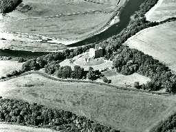
In medieval times there was a village at Horncliffe. At this time Horncliffe lay in an area of the county called Norhamshire and was under the control of the Bishops of Durham. The centre of this estate was Norham Castle which stands at the edge of the parish.
The importance of the Border did not stop with the Union of the Crowns in the 17th century. Tensions that later developed into conflict in the English Civil War, led to a temporary camp being built at West Loanhead. The 18th and 19th centuries saw big improvements in farming and some fine farms were built, such as Horncliffe Mains. The wealth that came from agriculture and industry at this time led to country houses being built including Morris Hall, Longridge Tower and the Palladian Horncliffe House.
Transport links were also improved in the post-medieval period with the arrival of the railway and Velvet Hall Station in the 19th century. The height of new technology was used for road links across the Tweed with an early suspension bridge called Union Chain Bridge.
N13833
UNCERTAIN
Disclaimer -
Please note that this information has been compiled from a number of different sources. Durham County Council and Northumberland County Council can accept no responsibility for any inaccuracy contained therein. If you wish to use/copy any of the images, please ensure that you read the Copyright information provided.
