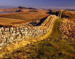
Section of Hadrian's Wall (Henshaw; Bardon Mill)
This section of Hadrian's Wall stretches from Turret 37a to Milecastle 39. Steep rock outcrops at Hotbank Crags, Highshields Crags and Peel Crags can be seen along the course of the wall. The wall survives as an exposed and repaired structure for most of this section. Fortifications on this section included Milecastle 38, Milecastle 39, Turret 37a, Turret 37b, Turret 38a, Turret 38b, Turret 39a and a further Roman tower. This is a Scheduled Monument.
N6674
EXCAVATION, West of Peel Gap 1986; CROW, J G
WATCHING BRIEF, Highshields Crag 2001; LANCASTER UNIVERSITY ARCHAEOLOGICAL UNIT
WATCHING BRIEF, Hotbank Farm 2005; Oxford Archaeology (North)
TOPOGRAPHIC SURVEY, Steel Rigg 2010; The Archaeological Practice Ltd
WATCHING BRIEF, Hadrian's Wall at Hotbanks 2016
WATCHING BRIEF, Watching brief during replacement of crossings on the Hadrian¿s Wall Trail at Crag Lough Wood 2017
WATCHING BRIEF, Hadrian¿s Wall Trail at Highshield Crags 2017
MANAGEMENT SURVEY, National Park Building at Risk Survey ; Sarah Dyer Heritage
WATCHING BRIEF, Land at Peel Cottage ; Historic Environment Research and Interpretation
WATCHING BRIEF, Cat Stairs and Peel Gap ; WallCAP
WATCHING BRIEF, Bradley Hall pond and feeder ditch ; Historic Environment Research and Investigation
WATCHING BRIEF, Crossing south of Cat Stairs ; Historic Environment Research and Interpretation
WATCHING BRIEF, Crossing below Crag Lough Wood ; Historic Environment Research and Interpretation
WATCHING BRIEF, Highshields Crags and Cat Stairs ; Historic Environment Research and Interpretation
Disclaimer -
Please note that this information has been compiled from a number of different sources. Durham County Council and Northumberland County Council can accept no responsibility for any inaccuracy contained therein. If you wish to use/copy any of the images, please ensure that you read the Copyright information provided.
