Local History
Wallington Demesne (Northumberland)

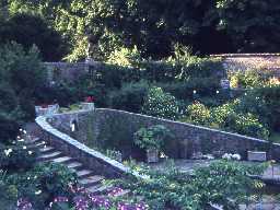
Wallington walled garden. Photo by Harry Rowland.

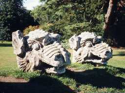
Dragon heads at Wallington. Photo by Northumberland County Council.

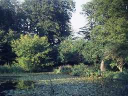
Pond at Wallington. Photo by Harry Rowland.
Wallington Demesne parish lies in mid-Northumberland and is dominated by the estate of Wallington Hall. The immediate area around Wallington Hall is improved farmland, landscaped grounds and woodland.
Mesolithic flints found by fieldwalking, suggest that people used the higher land to the south of the River Wansbeck at this time. They probably moved through the landscape according to the seasons, hunting animals and birds and collecting plants when in flower or fruit.
Evidence of a Neolithic presence comes from enigmatic rock art, known as cup and ring marked stones. Most have been found built into other structures, such as Paine's Bridge, Old Deanham and Middleton Bank Top and their original positions are therefore unknown. A standing stone with a possible cup mark may mark the transition from Neolithic to Bronze Age. Other standing stones once stood near Middleton South and north of Salter's Nick, although the one at Wallington was moved here in the 18th century. An exciting and important Bronze Age discovery was the famous Wallington hoard, which gave its name to a phase of the Bronze Age in northern Britain. Despite the introduction of metal, stone tools were also used at this time, such as the mace head from Cambo.
In the Iron Age there may have been a settlement at Salter's Nick where some earthworks have survived; it was probably used in the Roman period as well. Several other enclosures are likely to be of this date too, including Middleton Bank Top, Middleton Hill and Middleton Mill. They would have been small farms and the discovery of a quern used for grinding grain shows they were growing grains. A ford has been discovered near Highlaws on the line of the Devil's Causeway Roman road and another road may lie near Scot's Gap.
In medieval times people lived in villages and hamlets, such as Rugley Walls, Deanham and South Middleton. Remains of medieval fields, called ridge and furrow, survive as earthworks around some of these settlements and at South Middleton there are extensive remains of the now deserted village and field system. All around Wallington are fields of ridge and furrow, once thought exclusively medieval in date but now shown to be of several phases and nearly all of it has been modified in post-medieval times.
Northumberland was a battlefield in medieval times as England and Scotland fought each other and later border reivers wreaked their havoc too. Tower houses were built and later, defensive farmhouses called bastles, to protect some of the inhabitants. Wallington Hall stands on the site of a medieval tower and a the remains of a bastle at Cambo.
The peace that came to Northumberland in the later 17th century saw an investment in industry, farming and personal estates, such as Wallington. Wallington Hall was built on the proceeds of coal mining, lead mining and shipping. About 100 years after the house was built the present gardens were laid out by one of the most fashionable landscape gardeners of the 18th century, Capability Brown. The parkland includes follies like The Arches and eyecatchers, some at great distance from the house itself. Other buildings were more purposeful, such as the icehouse in the West Wood, and follies like the Arches. More decorative and curious features were placed around the grounds, including carved stone dragon heads, said to have been brought up from London as ship's ballast in returning coal boats.
Farming also began to develop more productive and innovative methods and a series of fine farmhouses and planned farms were built in the 18th and 19th century to meet these changing needs, at New Deanham, Corridge and Hartburn Grange. Coalmining and quarrying were important industries with a colliery at Cambo and the remains of the Bob Gin Pitt still visible on the estate. The owners of Wallington actively supported the creation of road and rail links in the 18th and 19th centuries with turnpikes from Rothbury to Hexham and Newcastle to Jedburgh nearby. A milestone at Cambo marks the distance between Rothbury and Hexham. The Wansbeck railway once ran through the parish on its way from Morpeth to Redesmouth; it also served local collieries and quarries which joined to it by tramways and waggonways.
The parish today is largely supported by farming and tourism as Wallington Hall and parts of its estate is owned and opened by The National Trust.
N13808
UNCERTAIN
Disclaimer -
Please note that this information has been compiled from a number of different sources. Durham County Council and Northumberland County Council can accept no responsibility for any inaccuracy contained therein. If you wish to use/copy any of the images, please ensure that you read the Copyright information provided.