South Middleton (Wallington Demesne)

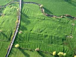
Aerial view of the earthwork remains of South Middleton deserted medieval village. Photo © Tim Gates.
NZ 053840 Deserted medieval village at Middleton, South. (1)
The turf covered remains of the village of South Middleton exist on both sides of the road to the south of Middleton Bridge. (2)
Visible on aerial photographs. (3)
The areas, centred at NZ 05358395 and NZ 05508402 respectively, contain a number of low turf-covered stony banks and platforms representing building foundations and associated crofts. Surveyed at 1/2500. (4)
South Middleton was a member of the lordship of Bolbec. It provided ten taxpayers in the 1296 Lay Subsidy. Thereafter, only the Reymes family holding was recorded during the Middle Ages.
The manor was acquired by the Fenwicks in 1609. An IPM of 1635 recorded that the vill comprised eight messuages and four cottages. There had been some shrinkage by 1666 - the Hearth Tax listed only nine houses. Mark's survey of 1734 recorded seven families; and the militia roll of 1762 listed three farmers in the township. Their farms were shown on Armstrong's map of 1769 - none stood on the site of the village.
Dispersal was probably in the period 1650-1750. The village site has been completely deserted. The earthworks are prominent but confused. A line of c.12 crofts running east-west is visible on aerial photos. Several house sites are evident at the north end of the crofts. To the south, a continuous perimeter bank divides the crofts from ridge and furrow. The green may have been to the east of the present road and to the north of the house sites. West of the present road lies a block of four crofts and house sites on the north of the green - the only evidence for more than one row of tenements. (5)
Deserted medieval village of South Middleton, NZ 053840. (6)
The road which cuts through the right-hand side of the settlement was constructed in the 18th century. (7)
Visible on aerial photographs. (8)
Scheduled. (9)
NZ 055 843. Deserted village of Middleton. Scheduled No ND/404. (10a)
N10588
FIELD OBSERVATION (VISUAL ASSESSMENT), Ordnance Survey Archaeology Division Field Investigation 1968; B H Pritchard
WATCHING BRIEF, South Middleton DMV ; Archaeological Research Services
WATCHING BRIEF, South Middleton DMV ; Archaeological Research Services
Disclaimer -
Please note that this information has been compiled from a number of different sources. Durham County Council and Northumberland County Council can accept no responsibility for any inaccuracy contained therein. If you wish to use/copy any of the images, please ensure that you read the Copyright information provided.