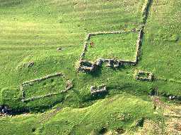
Branshaw Bastle and Branshaw deserted medieval village (Otterburn)
(NY 8803 9968) Peel (Remains of). (1)
The probable remains of a tower situated upon a gentle west slope of pasture in open moorland, at approx 900 feet above sea-level. The site overlooks falling ground to the north and south, and commands the opening to the Durtrees Burn valley which runs northwards. In the south west is low lying ground and to the east are rising slopes of moorland. A now-dry limestone ravine provides some natural defence, about 30m to the south-west.
The extant fragment comprises the greater part of the barrel-vaulted basement. The Peel, orientated nearly east-west, measures, overall. 12.2m by 7.4m. The walls are 1.5m thick, constructed of rough fashioned stones and boulders, with massive quoins at the corners. They stand to 3.5m height on the north and east sides, and area a tumbled mass of turf-covered masonry on the other sides. The south-west corner is intact to 2m height. The barrel roof is collapsed at the west end. The entrance, low and narrow, with bar holes, is in the east end. There is a retaining arch above the lintel stone. (2)
The barrel roof has now completely collapsed, otherwise as described. (3)
NY 880997 Remains of bastle. (See Type-site NY 88 SE 14). (4)
The byre doorway is in the centre of the east end; it has been square-headed, but the lintel has broken and partly fallen; a relieving arch above remains in a state of 'suspended collapse'. Part of a group including three other rectangular buildings, a corn-drying kiln(?) and several enclosure walls. On the edge of impact area of Otterburn ranges; recent deterioration may be due to shell fire. The whole site needs surveying. With a little repair work the bastle door could be cleared and consolidated. (5)
Additional references. (6,7,8,9,10,11)
Scheduled. (12)
Additional references. (13,14,15)
Listed by Cathcart King and by Dodds. (16a,b)
N8165
FIELD OBSERVATION (VISUAL ASSESSMENT), Ordnance Survey Archaeology Division Field Investigation 1957; A S Phillips
FIELD OBSERVATION (VISUAL ASSESSMENT), Ordnance Survey Archaeology Division Field Investigation 1970; D Smith
MEASURED SURVEY, BRANSHAW BASTLE AND DESERTED SETTLEMENT, OTTERBURN MILITARY TRAINING AREA 1996
TOPOGRAPHIC SURVEY, Branshaw Bastle and settlement 2004; Northern Archaeological Associates
BUILDING SURVEY, Branshaw Bastle and settlement 2004; Northern Archaeological Associates
FIELD SURVEY, Branshaw settlement wide area survey 2004; Northern Archaeological Associates
AERIAL INVESTIGATION AND MAPPING, Redesdale Lidar Landscapes project ; Oracle Heritage Services
Disclaimer -
Please note that this information has been compiled from a number of different sources. Durham County Council and Northumberland County Council can accept no responsibility for any inaccuracy contained therein. If you wish to use/copy any of the images, please ensure that you read the Copyright information provided.
