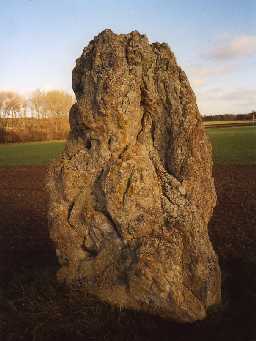
The King's Stone (Ford)
(NT 88423845) The King's Stone. (1)
The King's Stone, a prehistoric standing stone of cherty magnesian limestone, (2) is traditionally said to mark the spot where King James IV was killed at the Battle of Flodden Field. (3)
Scheduled. (4)
The stone is an isolated free standing stone measuring approximately 1m x 1.3m x 2.5m high, and is considerably weathered. It seems more likely to be of prehistoric origin, than a later commemorative stone. See G.P. Ao/66/42/2 for southern aspect. (5)
Scheduled. (6)
NT 884 384. The King's Stone, NW of Crookham, Westfield Farm. Scheduled no. ND/130. (7a)
N725
FIELD OBSERVATION (VISUAL ASSESSMENT), Ordnance Survey Archaeology Division Field Investigation 1967; E C Waight
Disclaimer -
Please note that this information has been compiled from a number of different sources. Durham County Council and Northumberland County Council can accept no responsibility for any inaccuracy contained therein. If you wish to use/copy any of the images, please ensure that you read the Copyright information provided.
