Hesley Well Farm lime kiln (West Allen)

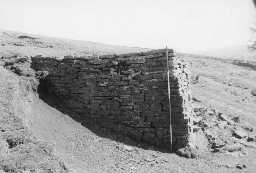
Side view of lime kiln 'B' at Hesley Well Farm. Photo by Lancaster University Archaeological Unit.

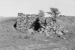
Partially collapsed lime kiln 'B' at Hesley Well Farm. Photo by Lancaster University Archaeological Unit.
The kiln stands just above the north east corner of a small wood, about 1km south of Hesley Well farm. It is a small field kiln of rough-coursed drystone construction, with a corbelled arch and a single collapsed eye. A poking hole is visible in the north side of the arch at 1.5m high. The north side of the kiln is intact, but the south has collapsed within the last five years. Stands to 2.2m height; built into the slope near small overgrown quarries to the south. The pot, though overgrown and infilled, is apparently round, 2m in diameter. A track runs north to south immediately below the kiln. (1)
Lime kiln. (2a)
Marked on 2nd editon OS map as an old quarry. (2b)
The remains of a post medieval lime kiln structure, with associated limestone quarry are visible as earthworks on air photographs and still extant on the latest 2002 vertical photography, centred at NY 7770 4935. (2c-d)
Lime kiln. (2a)
Marked on 2nd editon OS map as an old quarry. (2b)
The remains of a post medieval lime kiln structure, with associated limestone quarry are visible as earthworks on air photographs and still extant on the latest 2002 vertical photography, centred at NY 7770 4935. (2c-d)
N6328
THEMATIC SURVEY, North Pennines AONB lime kiln survey 2000; LANCASTER UNIVERSITY ARCHAEOLOGICAL UNIT
AERIAL PHOTOGRAPH INTERPRETATION, Altogether Archaeology project (Module 7: Allen Valleys and Hexhamshire Lidar Landscape Survey 2012-2015) 2015; Alogether Archaeology
FIELD SURVEY, RCHME: North Pennines Industrial Archaeology Project ; RCHME
AERIAL PHOTOGRAPH INTERPRETATION, Altogether Archaeology project (Module 7: Allen Valleys and Hexhamshire Lidar Landscape Survey 2012-2015) 2015; Alogether Archaeology
FIELD SURVEY, RCHME: North Pennines Industrial Archaeology Project ; RCHME
Disclaimer -
Please note that this information has been compiled from a number of different sources. Durham County Council and Northumberland County Council can accept no responsibility for any inaccuracy contained therein. If you wish to use/copy any of the images, please ensure that you read the Copyright information provided.