Iron Age defended settlement at Howick (Longhoughton)

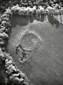
Howick Camp, Longhoughton. Photo © Tim Gates.

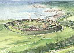
Reconstruction of Howick Iron Age settlement. Drawn by Terry Ball.
(NU25561632) Camp (Broken spears, Swords and Roman Coins found). (1)
A near circular camp at Howick with internal diameter of c.70 yards; entrance on west side. A ditch of 15 x - 20 x in width defended the north side, the south was naturally protected. Some pieces of old swords and a few ancient coins were found c.1817 when the interior was ploughed. (2)(a)
The earthwork is situated on a slight rise at the southern end of a wide spur. The natural defences to the south are good, with the ground sloping steeply to the stream. The earthworks themselves are weak and it is probable that the enclosure was constructed for pastoral uses, and probably native in origin.
The single rampart is of earth and stones, with an average width of 8m and a height varying from 0.6m to 1.2m. In the north west quadrant there are faint traces of what may have been an outer ditch but this area has been under the plough and no certain conclusions could be drawn.
The western entrance referred to is small and may be modern although it does give access to the stream which is the nearest water supply. There is another entrance on the east side, the bank to the south of which is inturned.
There are no traces of habitation in the enclosed area, or of any outer defences. The whole area is under pasture. (3)
Present whereabouts of finds, and authority for Roman classification of coins unknown. (4)
Listed under Pre-Roman Iron Age univallate [forts, settlements and enclosures]. (5)
The circular form, and proportions of the work, together with the construction of the enclosing feature are all similar to those found in a local type of Iron Age earthwork, which normally occupies a slightly elevated position, but in general fulfils a non-defensive function. Published survey (25 inch) revised. (6)
Howick Camp. Erosion visible on rampart edges needs examination. Cattle are trampling the banks. See slide X9. (7)
Schedueld. (8)
A preliminary geophysical survey was carried out in July 2002 to determine the effectiveness of magnetometry and resistivity survey techniques. Two ditches were recorded around the settlement but their extent and relationship is uncertain. The defensive walls were also recorded, but no entrance was located, although there is some evidence that there may have been a staggered entrance on the north side. There was also some evidence of stone features between the defences. (9)
A survey to establish the condition of the hillfort in 2002 concluded that it was in a reasonable state of preservation and that significant archaeological deposits probably survive. The remains are subject to a number of threats, including gorse, slippage and animal scrapes, ploughing, moles and rabbits, and abandoned waste. (10)
A survey carried out by The Conservation Team of Northumberland County Council during summer 1997 of the hillfort recorded the presence of possible building platforms within the interior of the hillfort, as well as an exposed part of the exterior face of the southern rampart. The remains of the walling were noted as slightly unstable at that date with the course apparently partly covered by gorse as well. A management agreement was proposed during 1998 for the removal of the gorse from the site. (11)
NU 256 164. Howick Hill. Listed in a gazetteer of British hillforts as a univallate structure enclosing 0.20ha. (12a)
NU 255 164. Howick camp. Scheduled No ND/431. (12b)
An Iron Age/Roman hillfort is visible as an earthwork on air photographs, centred at NU 2556 1632. The curvilinear enclosure is defined by a single internal bank with traces of an outer ditch, and has a maximum internal dimension of 50m. The feature is still extant on the latest 1999 Ordnance Survey vertical photography. (12c)
N5669
FIELD OBSERVATION (VISUAL ASSESSMENT), Ordnance Survey Archaeology Division Field Investigation 1955; E Geary
FIELD OBSERVATION (VISUAL ASSESSMENT), Ordnance Survey Archaeology Division Field Investigation 1969; B H Pritchard
FIELD SURVEY, Northumberland Coastal Survey 1992; GUARD
PHOTOGRAPHIC SURVEY, Northumberland Coastal Survey 1992; GUARD
TOPOGRAPHIC SURVEY, Howick Hillfort, Longhoughton 1997; Conservation Team
TOPOGRAPHIC SURVEY, Howick Hillfort Survey 2002; Howick Archaeology Project
GEOPHYSICAL SURVEY, Iron Age defended settlement, Howick Haven 2002; TIMESCAPE ARCHAEOLOGICAL SURVEYS
AERIAL PHOTOGRAPH INTERPRETATION, English Heritage: North East Coast NMP Rapid Coastal Zone Assessment Survey ; Archaeological Research Services
FIELD SURVEY, Hill forts and settlements in Northumberland ; G Jobey
Disclaimer -
Please note that this information has been compiled from a number of different sources. Durham County Council and Northumberland County Council can accept no responsibility for any inaccuracy contained therein. If you wish to use/copy any of the images, please ensure that you read the Copyright information provided.