Monastic Grange (Amble)
[Name centred NU 2624 0439] Benedictine monastery (Remains of). (1)
Amble - Manor of Tynemouth Priory. (2)
Tynemouth. Priory of Benedictine monks. (3)
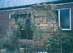
The prior and convent of Tynemouth undoubtedly possessed the old manor house [at Amble] which occupied a site on the brow of the bank or terrace which overhung the River Coquet. Of this house the only remains consist of a fragment of masonry, dating from 15th century, showing a window of two lights. (4)
I know little of the history of the remains situated near the church, except that they have monastic associations and have been scheduled as an ancient monument. (5)
[NU 26210439] The remains consist of a short length of wall running north west-south east. It measures 4.6m in length, 1m in thickness, with a maximum height of 3.5m and is constructed of roughly dressed stone with rubble filling. Set in the east face of this wall is a window of two trefoil headed lights.
From the information in T2 it would appear that this wall represents the sole remains of a Manor House or Grange of the Benedictine Priory of Tynemouth. (6)
[Subsequently published] Grange (site of). (7)
Condition unchanged. (8)
Ruined walls to east of Roman Catholic Church of Sacred Heart and St Cuthbert. Grade II listed building. Fragment of former Manor House, 15th century. 4m long and 2m high length of wall, 1m thick, containing a window of two trefoil headed lights with uncusped panels above.
The manor belonged to Tynemouth Priory and may have functioned as a monastic cell. From foundations exposed when the previous Catholic chapel was built in 1897 it would seem that the remaining wall formed part of a service wing adjoining the hall to the west. (9)
The Manor of Amble is reported from McAndrews 1912 Amble and District book as being granted to Tynemouth Priory in 1090. This land remain in the possession of the priory until the 15th century. (10)
This record includes National Record of the Historic Environment Information provided by Historic England on 4 January 2021 licensed under the Open Government Licence [www.nationalarchives.gov.uk/doc/open-government-licence/version/3/]
N5595
FIELD OBSERVATION (VISUAL ASSESSMENT), Ordnance Survey Archaeology Division Field Investigation 1954; E Geary
FIELD OBSERVATION (VISUAL ASSESSMENT), Ordnance Survey Archaeology Division Field Investigation 1971; B H Pritchard
DESK BASED ASSESSMENT, Gloster Hill, Amble 2015; Archaeological Services Durham University
FIELD OBSERVATION (VISUAL ASSESSMENT), Ordnance Survey Archaeology Division Field Investigation 1971; B H Pritchard
DESK BASED ASSESSMENT, Gloster Hill, Amble 2015; Archaeological Services Durham University
Disclaimer -
Please note that this information has been compiled from a number of different sources. Durham County Council and Northumberland County Council can accept no responsibility for any inaccuracy contained therein. If you wish to use/copy any of the images, please ensure that you read the Copyright information provided.
