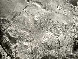
Roman period settlement on Brands Hill (Cheviotside)
(NT 97952455) Rectangular Homestead with round hut. (1)
NT 97932456. An irregular enclosure with single bank of earth and stone 3m to 4m wide and from 0.6m to 2m high with traces of revetting on the outside. The bank is longest in the vicinity of the entrance to the south-east, which is extremely well preserved and may have been excavated, having a revetted passage and paved floor.
Inside the enclosure is a hut circle 7m in diameter with a paved doorway to the south-east immediately opposite the entrance to the enclosure. The inside wall of the hut circle is two courses high in places. On the inside of the enclosure bank north of the entrance is a raised platform of earth and stones, possibly the remains of a later building.
The nearest water supply is the spring and small stream to the north-east.
Small enclosures with single hut circle in Northumberland are usually attributed to the native period. (2)
Brands Hill 3. Listed under Romano-British enclosed stone built settlements. (3)
A typical example of the local type of Romano-British homestead, with an orthostatic paved entrance. Surveyed at 1:2500. (4)
No change since reports of 1-10-55 and 26-8-69.
The similarity of construction, and the close proximity of a settlement to the south (see NT 92 SE 9), suggests the two sites are contemporary and associated, although there is no physical link between them.
Surveyed at 1:10,000 on MSD. (5)
SAM management agreement. (6)
Scheduled. (7)
NT 981245 Romano-British settlements and field systems and Medieval field systems on Brands Hill, NW of Old Middleton; scheduled. (8a)
General association with HER 1721. (8)
N1717
FIELD OBSERVATION (VISUAL ASSESSMENT), Ordnance Survey Archaeology Division Field Investigation 1955; E Geary
FIELD SURVEY, Rectilinear earthworks in Northumberland: some Medieval and Later settlements 1960; JOBEY, G
FIELD OBSERVATION (VISUAL ASSESSMENT), Ordnance Survey Archaeology Division Field Investigation 1969; D Smith
FIELD SURVEY, Rectilinear earthworks in Northumberland: some Medieval and Later settlements 1960; JOBEY, G
FIELD OBSERVATION (VISUAL ASSESSMENT), Ordnance Survey Archaeology Division Field Investigation 1969; D Smith
Disclaimer -
Please note that this information has been compiled from a number of different sources. Durham County Council and Northumberland County Council can accept no responsibility for any inaccuracy contained therein. If you wish to use/copy any of the images, please ensure that you read the Copyright information provided.
