Netherwitton (Netherwitton)
[Marginal]. The old market town of Netherwitton stood on the north side of the water between the chapel and the mill; and very old people remember when its site was cleared of old ground-works, weeds and rubbish. The mill and cottage near the chapel are the only remains.
The present village is perhaps not older than 1698, the date upon the cross. (1)
In 1710 Netherwitton was deemed to consist of 19-1/2 farms, of these 5-1/2 formed a part of the charity estate. [In the above the word 'farm' expresses merely a parcel of land uncertain both as to extent and value]. 'Netherwitton village in the beginning of the 18th century'. [Sketch map - not to scale, author anon - of village prior to desertion. An accompanying map shows the village in the middle of the 19th century at its present site]. (2)
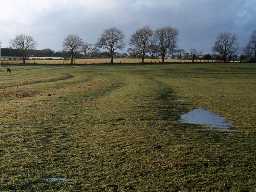
Area centred NZ 10179027. Site of village as described by authority 1 and depicted by authority 2 is now parkland fronting Netherwitton Hall.
There are no surface irregularities which might be associated with the original village. The mill and cottage referred to by authority 1 were investigated but appear to be 18th/19th century in construction and of no architectural note.
The present village contains no buildings of age or distinction. The reason for desertion would appear to emparking. (3)
Netherwitton deserted medieval village, NZ 100904. (4)
Air photographs taken in 2005 show upstanding areas of ridge and furrow cultivation, centred at NZ 696 907 and NZ 699 899, to the west and south of the current village of Netherwitton. Additionally there is a sub-circular enclosure defined by a ditch and external bank situated at NZ 0958 9072, this possibly represents a stack stand. (5a)
N11374
AERIAL RECONNAISSANCE, EH Aerial Reconnaissance (North): 2005-6
Disclaimer -
Please note that this information has been compiled from a number of different sources. Durham County Council and Northumberland County Council can accept no responsibility for any inaccuracy contained therein. If you wish to use/copy any of the images, please ensure that you read the Copyright information provided.
