Lordenshaws West (Whitton and Tosson)
(NZ 05249915) Cup and ring marked stones. (1)
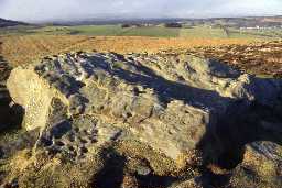
On the west side of the 13th century deer park wall, about 240yds WSW from the camp (NZ 09 NE 2) a large rock covered with cup and ring markings partly quarried away. This rock has been known since the 1850s. It contains more elaborate patterns and types of cup markings than any other in Coquetdale and shows the closest analogies to the petroglyphs of North Northumberland. (2)
There are two rocks concerned. The largest, to the north east, measures about 5m x 4m and its upper surface is literally covered with markings. These include single cups, cups with single, double and treble rings, cups within a horseshoe-shaped groove, basins and winding ducts. The rock is on the summit of a rise and is a prominent object.
The second rock to the south west measures about 3m x 1m. The markings consist of a cup with single ring and two, possibly three, single cups. (3)
Published survey (25 inch) correct. See additional photograph. (4)
Lordenshaws West outcrop, with cup and ring marks and cups. Main rock (with DoE sign on top). (5)
This rock lies within the area surveyed by RCHME in December 1990 and is briefly discussed in the published report where it is noted that this outcrop has been quarried so that some carvings may have been lost. (6a)
West Lordenshaw 2a-fH00681NZ 0524 9916
The whole of this ridge, an outcrop of freestone, has been quarried, so that any survivals are fortunate.
East Lordenshaw 3H00682NZ 0526 9909
This outcrop ridge, quarried in places, is a dramatic feature of the area, and the exposed rock is grey to white. The exposure of sloping sandstone has led prehistoric people to think of making long grooves and channels, toghether with large cups and cups and rings - characteristics that extend to sites overlooking the Whitton Burn as it joins the Coquet, and the old golf course to the north.(6b)
Additional reference. (7)
N10738
FIELD OBSERVATION (VISUAL ASSESSMENT), Ordnance Survey Archaeology Division Field Investigation 1956; E Geary
FIELD OBSERVATION (VISUAL ASSESSMENT), Ordnance Survey Archaeology Division Field Investigation 1971; B H Pritchard
TOPOGRAPHIC SURVEY, Lordenshaws Hillfort and Its Environs 1990; RCHME
AERIAL INVESTIGATION AND MAPPING, Lordenshaw ; Archaeological Services Durham University
GEOPHYSICAL SURVEY, Lordenshaw ; Archaeological Services Durham University
Disclaimer -
Please note that this information has been compiled from a number of different sources. Durham County Council and Northumberland County Council can accept no responsibility for any inaccuracy contained therein. If you wish to use/copy any of the images, please ensure that you read the Copyright information provided.
