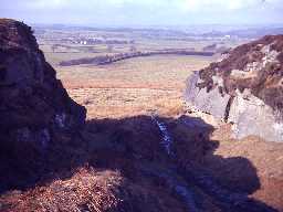
Salter's Nick Iron Age and Romano-British settlement (Wallington Demesne; Capheaton)
(NZ 05358235) Camp. (1)
'Salter's Nick'. An irregular-shaped earthwork with a single rampart, approximately one acre in area. (Listed under Native Sites in Northumberland). (2)
A promontory fort, the interior of which contains the remains of many circles and enclosures, all to the south of the modern road cutting through it. (3)
An irregular-shaped enclosure abutting a rocky escarpment and generally in poor condition. It consists of a single, weak outer bank to the north and east terminating at either end at the cliff edge. The interior is divided by a complex of stony banks with four visible hut circles.
Its general form and construction are consistent with the remains of a Romano-British settlement, rather than a fort.
Published survey (25 inch) revised. (4)
D-shaped enclosure. Huts mentioned by Jobey not found, nor located on modern aerial photographs. Earthwork cut by the Salters Road, a later trackway, in part used as a waggonway. (5)
Scheduled. (6)
The site was surveyed by J Davies and J Noble in May 1992. There is a field system on the north side of the enclosure, which may be contemporary with the fort. (Description of fort). (7)
Scheduled as a Romano-British settlement and Iron Age defended settlement. (8a)
N10587
FIELD OBSERVATION (VISUAL ASSESSMENT), Ordnance Survey Archaeology Division Field Investigation 1968; B H Pritchard
FIELD SURVEY, Survey of Bolam and Shaftoe Area 1989; DAVIES, J
FIELD SURVEY, Survey of Bolam and Shaftoe Area 1989; DAVIES, J
Disclaimer -
Please note that this information has been compiled from a number of different sources. Durham County Council and Northumberland County Council can accept no responsibility for any inaccuracy contained therein. If you wish to use/copy any of the images, please ensure that you read the Copyright information provided.
