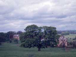
Kirkharle Hall landscape park (Kirkwhelpington)
Remnants of landscape pleasure grounds and park, c80ha, 1718-43 by Williams Loraine, 2nd Bart, and probably by Capability Brown for the 4th Bart. The park is now divided into two roughly equal areas - Little Harle Park and Kirkharle Hall (Farm).
A shelterbelt to Kirkharle Hall and trees in surrounding farmland are the remains of tree planting 1718-43. The remains of landscape park for 4th Bart lie north of the house, drive to church, landscaped valley and plantations, attributed to Brown. Village removed and rebuilt on higher ground by 4th Bart. A plan of c.1770 shows the former layout of formal gardens and proposed improvements. No evidence the scheme was implemented. This was the site of Capability Brown's first employment, 1732-9, as a member of estate staff. (1)
Additional bibliography. (2)
Landscape park and pleasure grounds to Kirkharle Hall covering an area of 80 hectares.The grounds were laid out between 1718-43 and altered during the mid-late 18th century including possible work by Lancelot Brown circa 1763. The park was extended in the 1830s. (3)
Additional reference. (4)
N10507
MANAGEMENT SURVEY, Kirkharle and Little Harle 1993; Groundwork North East
DESK BASED ASSESSMENT, Green Rigg Wind Farm 2006; Northern Archaeological Associates
ENVIRONMENTAL IMPACT ASSESSMENT, Steadings windfarm 2007; Oxford Archaeological Associates
GEOPHYSICAL SURVEY, Kirkharle Pele Tower 2008; Archaeological Services Durham University
DESK BASED ASSESSMENT, Green Rigg Wind Farm 2006; Northern Archaeological Associates
ENVIRONMENTAL IMPACT ASSESSMENT, Steadings windfarm 2007; Oxford Archaeological Associates
GEOPHYSICAL SURVEY, Kirkharle Pele Tower 2008; Archaeological Services Durham University
Disclaimer -
Please note that this information has been compiled from a number of different sources. Durham County Council and Northumberland County Council can accept no responsibility for any inaccuracy contained therein. If you wish to use/copy any of the images, please ensure that you read the Copyright information provided.
