White Hill and Laddies Knowe cultivation terraces (Kirknewton)
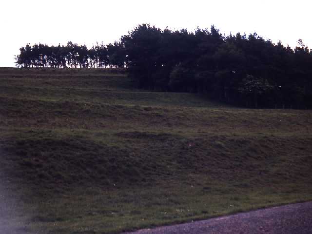
Cultivation terraces near Hethpool. Photo by Harry Rowland.
(Centred NT 889 287) Cultivation Terraces. (1)
These cultivation terraces occupy an extensive area of south and south-east slopes. They vary in width from 10m to 25m with the level working width varying from 8m to 12m.
Where the terraces merge with the more level ground they sometimes continue as ridge and furrow ploughing 8m to 10m wide. This ridge and furrow differs from that usual in the region in that it is wider and follows the contours. The narrower and comparatively modern ploughing
follows the slope and is usually for drainage purposes.
The wider ridge and furrow is usually associated with medieval strip cultivation and it seems probable that this ploughing and the terraces are of this period and possibly associated with the depopulated medieval village of Hethpool (NT 82 NE 50). (2)
Condition unchanged. (3)
No change.See G.P. (4)
Well preserved cultivation terraces on south and east slopes of White Hill and Laddie's Knowe (between cNT 895289 and cNT 880285). Form a continuous band of cultivation. Superseded in some areas by narrow-rigg cultivation.
A series of features overlies the terraces, eg hut circle [NT 82 NE 109]. The hillfort(?) [NT 82 NE 68] may be contemporary with terracing as the perimeter of the hillfort is respected. Cross contour rig and furrow cuts through and destroys several areas of terracing:-
NT 89502870, NT 89052880, NT 88502850 and NT 88202830. (5)
A series of very well preserved cultivation terraces lie on the hill slopes to the south-east of
NT 82 NE 68. It has been suggested that this terracing is contemporary with the hill fort (see authority 5). However, the full extent of the terraces has not been surveyed and their relationship to the settlements are not fully understood. The area would benefit from detailed field survey. (6)
These cultivation terraces occupy an extensive area of south and south-east slopes. They vary in width from 10m to 25m with the level working width varying from 8m to 12m.
Where the terraces merge with the more level ground they sometimes continue as ridge and furrow ploughing 8m to 10m wide. This ridge and furrow differs from that usual in the region in that it is wider and follows the contours. The narrower and comparatively modern ploughing
follows the slope and is usually for drainage purposes.
The wider ridge and furrow is usually associated with medieval strip cultivation and it seems probable that this ploughing and the terraces are of this period and possibly associated with the depopulated medieval village of Hethpool (NT 82 NE 50). (2)
Condition unchanged. (3)
No change.See G.P. (4)
Well preserved cultivation terraces on south and east slopes of White Hill and Laddie's Knowe (between cNT 895289 and cNT 880285). Form a continuous band of cultivation. Superseded in some areas by narrow-rigg cultivation.
A series of features overlies the terraces, eg hut circle [NT 82 NE 109]. The hillfort(?) [NT 82 NE 68] may be contemporary with terracing as the perimeter of the hillfort is respected. Cross contour rig and furrow cuts through and destroys several areas of terracing:-
NT 89502870, NT 89052880, NT 88502850 and NT 88202830. (5)
A series of very well preserved cultivation terraces lie on the hill slopes to the south-east of
NT 82 NE 68. It has been suggested that this terracing is contemporary with the hill fort (see authority 5). However, the full extent of the terraces has not been surveyed and their relationship to the settlements are not fully understood. The area would benefit from detailed field survey. (6)
N612
FIELD OBSERVATION (VISUAL ASSESSMENT), Ordnance Survey Archaeology Division Field Investigation 1955; E Geary
FIELD OBSERVATION (VISUAL ASSESSMENT), Ordnance Survey Archaeology Division Field Investigation 1967; R W Emsley
FIELD OBSERVATION (VISUAL ASSESSMENT), Ordnance Survey Archaeology Division Field Investigation 1979; I S Sainsbury
HISTORIC AREA ASSESSMENT, Hethpool Village Atlas (HISTORIC BERWICK VILLAGE ATLAS) ; The Archaeological Practice Ltd
FIELD OBSERVATION (VISUAL ASSESSMENT), Ordnance Survey Archaeology Division Field Investigation 1967; R W Emsley
FIELD OBSERVATION (VISUAL ASSESSMENT), Ordnance Survey Archaeology Division Field Investigation 1979; I S Sainsbury
HISTORIC AREA ASSESSMENT, Hethpool Village Atlas (HISTORIC BERWICK VILLAGE ATLAS) ; The Archaeological Practice Ltd
Disclaimer -
Please note that this information has been compiled from a number of different sources. Durham County Council and Northumberland County Council can accept no responsibility for any inaccuracy contained therein. If you wish to use/copy any of the images, please ensure that you read the Copyright information provided.