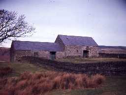
Whitlees bastle (Elsdon)
(NY95989263) Peel (remains of). (1)
Pele at Whitlees. (2)
The remains of a strongly built structure originally of two stories now converted into a barn, measures overall 11.5m by 7.4m. The walls are 1.3m thick at ground level, narrowing to 1.1m at first floor level. They are of uncoursed, unbounded stones with massive quoins at the corners. The original entrance, now blocked, is in the east end. See photograph.
The plan of the building and the absence of barrel vaulting suggest the structure to be a defended house rather than a Peel tower. Similar structures have been dated to the Tudor period. (3)
Condition unchanged. (4)
NY959927 Bastle. (See Type-site NY 88 SE 14) (5)
In south wall is 19th century cart entrance, with small iron-grilled window to west; smaller blocked window above. Gables reduced (in 19th century although side walls seem to remain to their original height. This seems to be a defensible farmhouse with ground-floor accommodation, rather than a true bastle. (6)
Bastle house c.50 yards north of Whitlees. Grade II listed Bastle, now used as a store. 16th or early 17th century, reduced in height and reroofed in 19th century. Built of massive random rubble with a boulder plinth and a Welsh slate roof. The walls are about 54 inches (1.37m) thick for the first 7 feet (2.13m). (7)
A late 16th or early 17th century bastlehouse. Built of large roughly-soursed rubble, with Welsh slate roof. Reduced in height and now used as a store. Large 19th century or early 20th century double door cut through south wall. Original features include the dramatic masonry, one small square window with a chamfered surround and its original grille of iron bars (a very rare feature), and the blocked ground floor doorway under a relieving arch on the gable end. Walls are about 4 feet thick. Ther eis an 18th or 19th century byre attached to left. (8)
It is difficult to ascertain what sort of defended house this was, although the plan is bastle-like. Listed by Cathcart King and by Dodds. (9a-b)
N9780
Post Medieval (1540 to 1901)
20th Century (1901 to 2000)
20th Century (1901 to 2000)
FIELD OBSERVATION (VISUAL ASSESSMENT), Ordnance Survey Archaeology Division Field Investigation 1957; A S Phillips
HISTORIC AREA ASSESSMENT, Elsdon Village Atlas ; The Archaeological Practice Ltd
MANAGEMENT SURVEY, National Park Building at Risk Survey ; Sarah Dyer Heritage
HISTORIC AREA ASSESSMENT, Elsdon Village Atlas ; The Archaeological Practice Ltd
MANAGEMENT SURVEY, National Park Building at Risk Survey ; Sarah Dyer Heritage
Disclaimer -
Please note that this information has been compiled from a number of different sources. Durham County Council and Northumberland County Council can accept no responsibility for any inaccuracy contained therein. If you wish to use/copy any of the images, please ensure that you read the Copyright information provided.
