Steng medieval wayside cross (Rothley with Hollinghill; Elsdon)
(NY 96199078) Steng Cross (Remains of). (1)
'Sting Cross', on the height between Elsdon and Cambo, is on the ancient and present way to Newcastle. The pedestal remains. (2)
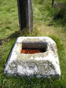
A cross-base situated south of the modern road in the south-west corner of a field. It measures 0.8m square chamfered down to 0.6m square, and stands to 0.4m above ground level, the socket stone is 0.4m by 0.25m and is 0.2m deep. There are no traces of the shaft or cross. See photograph. (3)
From its situation on the ground this cross-base is conjectured to be the remains of a wayside cross. (4)
Condition unchanged. (5)
NY 9621 9076. Steng medieval wayside cross. Scheduled RSM No 25025. (6)
Crossbase of Steng Cross, grade II. The cross base is medieval and made of sandstone. (7)
The cross indicates a focal point in the early medieval landscape and may have emphasised, rather than marked anew, a boundary along the Rede/Wansbeck watershed between contemporary estates. (8)
N9777
FIELD OBSERVATION (VISUAL ASSESSMENT), Ordnance Survey Archaeology Division Field Investigation 1957; A S Phillips
FIELD SURVEY, HARTINGTON MOOR, WALLINGTON HALL ESTATE 1996; P J Fowler and K D Strutt
WATCHING BRIEF, Erection of Wind Monitoring Masts for the Proposed Ray Wind Farm Development 2007; CFA Archaeology Ltd
HISTORIC AREA ASSESSMENT, Elsdon Village Atlas ; The Archaeological Practice Ltd
FIELD SURVEY, HARTINGTON MOOR, WALLINGTON HALL ESTATE 1996; P J Fowler and K D Strutt
WATCHING BRIEF, Erection of Wind Monitoring Masts for the Proposed Ray Wind Farm Development 2007; CFA Archaeology Ltd
HISTORIC AREA ASSESSMENT, Elsdon Village Atlas ; The Archaeological Practice Ltd
Disclaimer -
Please note that this information has been compiled from a number of different sources. Durham County Council and Northumberland County Council can accept no responsibility for any inaccuracy contained therein. If you wish to use/copy any of the images, please ensure that you read the Copyright information provided.
