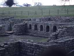
Chesters Bath House (Cilurnum Bath House) (Humshaugh)
(Previously recorded by the Ordnance Survey as NY 97 SW 5.1)
(NY 9129 7008) Bath House (G.S.C.) (1)
The main bath-house was built some distance outside the fort (Cilurnum; NY 97 SW 5) on a shelf quarried out of the bank side a short way downstream from the bridge (NY 97 SW 4), with its main entrance opening on to the Military Way. The west wall of the building is standing up to 10ft high in places, but elsewhere, stone robbing in post-Roman times has reduced it considerably. (2)
Thirty three human skeletons and an altar dedicated to the goddess Fortune have been found in former excavations. (3)
A well preserved bath-house in the care of the Ministry of Works and open to the public. Published survey (25 inch) revised. (4)
Scheduled. (5)
The bath house remains are of at least two stone phases in construction. Article highlights the development of this bath house (as typical of other military bath houses, both on and off Hadrian's Wall) in a developed stone construction (though the possibility of other timber phases and remains is noted), and draws attention to the possible social reasons behind the expansion of the building. (6)
An article summarising and synthesising the previous excavations in the Roman bath house was published in Archaeologia Aeliana Series 5 Volume 45. (7)
The bath house was discovered by chance and excavated in the 1880s (8b) and described in detail (8c). The structure was consolidated in 1957-8. Few fresh observations were made on the bath house in the course of the 1992-3 RCHME survey, except that it is considerably less rectangular than previously published plans suggest. The walls stand to a maximum height of 3m, indicating the depth of hillwash on the slope and suggesting that other buildings may be similarly masked. The discovery of human and animal bones in the bath house was apparently not adequately recorded and has not been discussed in the literature. A wall stub projecting from the W side of the excavation cutting has also been largely ignored. Further description and discussion is included in the archive account accompanying the 1992-3 RCHME plan. (8a)
A Roman bath house is visible as a demolished building on air photographs. The remains are as described by authorities 1-5. (8d)
Located on the English Heritage map of Hadrian's Wall 2010. (8e)
N9338
EXCAVATION, Chesters Bath-House 1930; North of England Excavation Committee
FIELD OBSERVATION (VISUAL ASSESSMENT), Ordnance Survey Archaeology Division Field Investigation 1967; D Smith
AERIAL PHOTOGRAPH INTERPRETATION, English Heritage: Hadrian's Wall WHS Mapping Project, NMP 2008; English Heritage
WATCHING BRIEF, Chesters Fort Bath-House 2012; TWM Archaeology
EXCAVATION, Chesters Bath-house
EXCAVATION, Chesters Bath House
MEASURED SURVEY, RCHME: Chesters Roman Fort Survey ; RCHME
MEASURED SURVEY, RCHME: Hadrian's Wall Project ; RCHME
Disclaimer -
Please note that this information has been compiled from a number of different sources. Durham County Council and Northumberland County Council can accept no responsibility for any inaccuracy contained therein. If you wish to use/copy any of the images, please ensure that you read the Copyright information provided.
