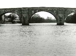
Chollerford Bridge with remains of medieval bridge and abutments of previous bridge (Humshaugh; Wall)
(NY91967051) Piers of Old Bridge (L.B.) (1)
Chollerford Bridge, repaired in 1394, was washed away in 1771 and shortly replaced by the present structure. (2)
The remains of the early bridge consist of the terminal buttresses, and two piers, south-west of the modern one. See photograph and sketch. (3)
Chollerford Bridge, over River Tyne North. Grade II. Bridge, 1785 by Robert Mylne. Squared stone. 5 stepped round arches with triangular cutwaters, their upper parts set back and carried up as refuges. Band below parapet, which has gabled coping, ramped down at north-west end, and terminates in low rectangular piers with pyramidal caps. Erected after its predecessor was destroyed in the flood of 1771. (4)
Chollerford Bridge with abutments of previous bridge, SAM Northum 111. A bridge erected in 1775 to carry the Military Road over the North Tyne in place of that destroyed by the flood of 1771. This is one of the most beautiful bridges in Northumberland. Condition good but the second arch from the east end has slightly sagged.
The end abutments and foundations of a bridge which was destroyed by the great flood of 1771. The lower part of the west abutment may be seen. This bridge may have been built to carry the Military Road c.1753. (5)
Chollerford Bridge is constructed of squared and tooled-and-margined stone, many blocks bear mason's marks, of a variety of types; a number show only parts of mason's marks or (arabic) incised numbers, implying they have been reused in their present context. Detailed description of bridge. (6)
Additional references. (7)
N9296
FIELD OBSERVATION (VISUAL ASSESSMENT), Ordnance Survey Archaeology Division Field Investigation 1966; R W Emsley
ARCHITECTURAL SURVEY, HISTORIC BRIDGES SURVEY 1992; P RYDER
PHOTOGRAPHIC SURVEY, HISTORIC BRIDGES SURVEY 1992; P RYDER
ARCHITECTURAL SURVEY, HISTORIC BRIDGES SURVEY 1992; P RYDER
PHOTOGRAPHIC SURVEY, HISTORIC BRIDGES SURVEY 1992; P RYDER
Disclaimer -
Please note that this information has been compiled from a number of different sources. Durham County Council and Northumberland County Council can accept no responsibility for any inaccuracy contained therein. If you wish to use/copy any of the images, please ensure that you read the Copyright information provided.
