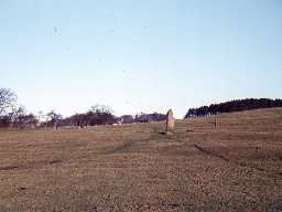
Standing stone, 770m south-east of Swinburne Castle (Chollerton)
(NY 93757454) Standing Stone (L.B.) (1)
Cup-markings on an eroded standing stone at Swinburne. (2)
The stone bears three definite cup-markings on the south-east face. See photograph. (3)
NY 937746. Possible cup marks on the Swinburne standing stone. (4)
A number of simple cup-markings on the standing stone. (5)
Scheduled. (6)
The site was recorded in a Rock Art survey carried out by the North of the Wall Tynedale Archaeology Group as part of the Beyond the Wall: Edges Green Project. The site was recorded as Swinburne Standing Stone. A scatter of 10-12 cups were recorded, mostly on the south-east face of the stone with c.8 of the cups in a loose cluster. Many of the cups were elongated, possibly by water erosion, which is extensive. (7)
Swinburne Standing Stone H00768 NY 9390 7460
The largest standing stone in the county, on private land, has cup marks on its north and south faces. It stands in an intreguing landscape of cultivation terraces and burial cairns. The north face has four ovals and about 15 other cups, some small; there are two prominent cups on the south face and 10 faint cups. (8a)
A prehistoric standing stone is visible as a structure on air photographs at NY 9375 7454. (8b)
N9290
FIELD OBSERVATION (VISUAL ASSESSMENT), Ordnance Survey Archaeology Division Field Investigation 1966; R W Emsley
ENVIRONMENTAL IMPACT ASSESSMENT, Steadings windfarm 2007; Oxford Archaeological Associates
AERIAL PHOTOGRAPH INTERPRETATION, English Heritage: Hadrian's Wall WHS Mapping Project, NMP 2008; English Heritage
THEMATIC SURVEY, Tynedale Rock Art Project 2017; Tynedale Archaeology Group
ENVIRONMENTAL IMPACT ASSESSMENT, Steadings windfarm 2007; Oxford Archaeological Associates
AERIAL PHOTOGRAPH INTERPRETATION, English Heritage: Hadrian's Wall WHS Mapping Project, NMP 2008; English Heritage
THEMATIC SURVEY, Tynedale Rock Art Project 2017; Tynedale Archaeology Group
Disclaimer -
Please note that this information has been compiled from a number of different sources. Durham County Council and Northumberland County Council can accept no responsibility for any inaccuracy contained therein. If you wish to use/copy any of the images, please ensure that you read the Copyright information provided.
