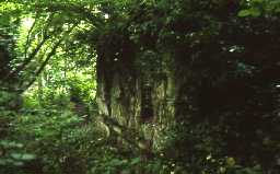
Old bridge remains on west bank of Devil's Water (Corbridge)
There was a pack-horse bridge, seemingly 14th century at Dilston. It crossed the Devil's Water, close to the Mill, by a roadway only 8ft 6ins wide supported by three ribs. Part of a pier still remains. (1)(2)
NY 97556343 The remains consist of two portions of old masonry (i) the springing of the arch on the land west side, with a horizontal 'string-course' 1m from the base. (ii) 6.5m distant across a mill-race and on the edge of the river, is a massive pier now mainly reduced to a pile of rubble. It also bears a fragment of a 'string-course' and traces of an arch springing 0.2m from the ground. The fragment is 2m high. No other remains are visible in the river, or on the east bank (Remains of the later, now-demolished footbridge are however visible). (3)
Condition unchanged. See Illustrations Card. (4)
Remains of old bridge on west bank of Devil's Water 120m south of A695 bridge, grade II listed building. Probably 14th century, altered in 19th century. Lower parts of west abutment and adjacent pier. Condition unchanged. (5)
N9014
FIELD OBSERVATION (VISUAL ASSESSMENT), Ordnance Survey Archaeology Division Field Investigation 1956; J L Davidson
FIELD OBSERVATION (VISUAL ASSESSMENT), Ordnance Survey Archaeology Division Field Investigation 1966; R Lewis
FIELD OBSERVATION (VISUAL ASSESSMENT), Ordnance Survey Archaeology Division Field Investigation 1966; R Lewis
Disclaimer -
Please note that this information has been compiled from a number of different sources. Durham County Council and Northumberland County Council can accept no responsibility for any inaccuracy contained therein. If you wish to use/copy any of the images, please ensure that you read the Copyright information provided.
