High Rochester Roman Fort (Bremenium, Bremenivm) (Rochester and Byrness)

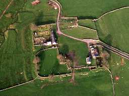
Aerial view of High Rochester Roman fort. Photo © Tim Gates.

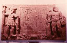
Inscription of the 20th Legion, High Rochester. Copyright Reserved: Museum of Antiquities, Newcastle upon Tyne.

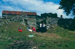
A gateway at High Rochester Roman fort being surveyed by Newcastle University students in 1993. Photo by Northumberland County Council.
(NY 832986) Bremenium Roman fort [R]. (1)
Bremenium Roman fort measuring circa 482ft by 445ft across the defensive walls excavated in 1852, 1855 and 1935.
Flavian-Trajanic period. The original Agricolan Fort (AD 78-85) consisted of a single ditch and rampart, later demolished and replaced by a larger rampart and elaborate ditch system.
Antonine period (AD 139-late 2nd century). Fort rebuilt with rubble wall, backed by a clay rampart. In 1935, a 19ft road behind the wall and an L-shaped barrack block were discovered.
Severan period (early 3rd-late 3rd century). Original defences levelled and a new fort wall built. Most of the excavated internal buildings belong to this phase. See Constantinian period (c.306 AD-mid 4th century). Fort rebuilt with strong stone wall, four gateways and angle and interval turrets. The internal layout generally repeated the plan of earlier buildings. Fort destroyed in mid-4th century and never restored. Six ditches of unknown period were found in 1935 on the north side of the fort. On the east and south sides were three larger ditches unrelated to those on the north. (2)
Various inscribed stones have been found within or near the Roman fort at High Rochester. Details given. The stones are held by various museums throughout the country. (3)
The fort has been badly mutilated but the main rampart can still be seen throughout. Stretches of Roman walling are visible in the west side, and gateways still exist on the north and west sides. Remains of an interval turret to the west of the south gate and possible remains of an angle turret within the south east angle of the fort are also visible. Published survey (25 inch) revised. (4)
Name 'BREMENIVM' accepted for 4th edition Roman Britain Map. (5)
No change since reports of 13.9.56 and 6.11.70. (6)
Additional references. (7-20)
Scheduled. (21)
Additional reference. (22)
High Rochester Roman Fort (formerly listed as Remains of Walling at High Rochester or Bremenium). Grade II. Roman fort, founded in the first century AD with restorations and rebuildings throughout the C2, C3 and C4. Ashlar. The mound of the fort is intact with lower parts of walls visible in many places. The west gateway stands to c.5ft with massive masonry of the flanking towers flush with adjoining wall; north impost stands in situ with moulded impost block and the springer of the arch. South internal tower between south gate and south-west angle of the fort also has extensive visible remains. The front of the tower has gone but the sides and back remain up to the height of a blocked doorway at 1st floor level. Jambs of north and south gates also visible. (23a)
General association with HER 8092 (mausolea); HER 12392 (Dere Street). (23)
Excavation in 2021 near the south-west corner of the fort found evidence of Roman activity in the form of ditches and gulleys (one containing a line of stakes), possibly associated with control of water from the fort and for ditches; Roman pottery and glass waste, suggestive of manufacturing, was also found here. Remains of a lime kiln were found (see HER 35452) near the west fort rampart. Further north, excavation examined the site of two apprarent annexe enclosures seen on geophysical survey plots. A turf rampart and ditch was found, in whose waterlogged fill a 2nd century AD Roman shoe was found; a flagged floor and with burnt clay above may indicate a bakehouse or oven. Palaeoenvironmental analysis revealed small background levels of waste associated with occupation, rather than large deposits of settlement debris. (24)
Bremenium (High Rochester) Roman fort. Ramparts and other features show up clearly on lidar imagery. (25)
N8091
EXCAVATION, HIGH ROCHESTER, (BREMENIUM) 1852; TAYLOR, T J
EXCAVATION, HIGH ROCHESTER (BREMENIUM) 1855; Society of Antiquaries of Newcastle
EXCAVATION, Low Cleughs bastle and High Rochester 1935; North of England Excavation Committee
FIELD OBSERVATION (VISUAL ASSESSMENT), Ordnance Survey Archaeology Division Field Investigation 1970; D Smith
FIELD OBSERVATION (VISUAL ASSESSMENT), Ordnance Survey Archaeology Division Field Investigation 1977; S Ainsworth
EXCAVATION, High Rochester Roman fort 1981; CHARLTON, D B
TOPOGRAPHIC SURVEY, High Rochester 1992; University of Newcastle
GEOPHYSICAL SURVEY, HIGH ROCHESTER (BREMENIUM) 1993; GeoQuest Associates
TOPOGRAPHIC SURVEY, High Rochester 1993; University of Newcastle
GEOPHYSICAL SURVEY, High Rochester 1993; University of Newcastle
BUILDING SURVEY, High Rochester 1993; University of Newcastle
EXCAVATION, HIGH ROCHESTER (NW ANGLE) 1993; University of Newcastle
FIELD SURVEY, High Rochester 1994; University of Newcastle
GEOPHYSICAL SURVEY, HIGH ROCHESTER (BREMENIUM) 1995; GEOQUEST ASSOCIATES
DESK BASED ASSESSMENT, High Rochester Fort 1996; The Archaeological Practice
EXCAVATION, High Rochester 1997; Newcastle University
GEOPHYSICAL SURVEY, High Rochester Roman Fort 2003; Timescape Archaeological Surveys
TRIAL TRENCH, High Rochester Roman Fort 2010; The Archaeological Practice Ltd
WATCHING BRIEF, High Rochester Roman fort 2019; Alan Williams Archaeology
AERIAL INVESTIGATION AND MAPPING, Redesdale Lidar Landscapes project ; Oracle Heritage Services
WATCHING BRIEF, GREEN COTTAGE, HIGH ROCHESTER ; Central Excavation Unit
HISTORIC AREA ASSESSMENT, Rochester Village Atlas (Historic Tynedale Village Atlas) ; The Archaeological Practice Ltd
AERIAL INVESTIGATION AND MAPPING, Northern Frontiers ; Department of Archaeology, York University
MANAGEMENT SURVEY, National Park Building at Risk Survey ; Sarah Dyer Heritage
EXCAVATION, Land at High Rochester Roman Fort ; The Archaeological Practice Ltd
WATCHING BRIEF, Land adjacent to the West Gate of Bremenium Roman Fort ; The Archaeological Practice Ltd
MEASURED SURVEY, HIGH ROCHESTER ROMAN FORT ; The Archaeological Practice
GEOPHYSICAL SURVEY, HIGH ROCHESTER (BREMENIUM) ; GeoQuest Associates
Disclaimer -
Please note that this information has been compiled from a number of different sources. Durham County Council and Northumberland County Council can accept no responsibility for any inaccuracy contained therein. If you wish to use/copy any of the images, please ensure that you read the Copyright information provided.