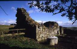
Lower Stobbylee bastle (Bellingham)
'NY 839809' A peel, or bastle at Shield Field. (1)
Shield Field at NY 83438047 is a recent farmhouse, but the remains of a bastle, measuring 10.5m x 6.8m, with walls 1.2m thick and 4m maximum height, are incorporated in a ruined farmstead, known as Low Stabbylee, at NY 83838071. See photographs. (2)
NY 838807 Remains of bastle. (See Type-site NY 88 SE 14). (3)
As described in report of 25.9.70 (see photograph). (4)
Detailed description. (5)
The bastle, known as Stobby Lea, is as described. (6a)
N7977
FIELD OBSERVATION (VISUAL ASSESSMENT), Ordnance Survey Archaeology Division Field Investigation 1970; D Smith
FIELD OBSERVATION (VISUAL ASSESSMENT), Ordnance Survey Archaeology Division Field Investigation 1977; S Ainsworth
THEMATIC SURVEY, Towers and Bastles in Northumberland 1995; P RYDER
FIELD OBSERVATION (VISUAL ASSESSMENT), Ordnance Survey Archaeology Division Field Investigation 1977; S Ainsworth
THEMATIC SURVEY, Towers and Bastles in Northumberland 1995; P RYDER
Disclaimer -
Please note that this information has been compiled from a number of different sources. Durham County Council and Northumberland County Council can accept no responsibility for any inaccuracy contained therein. If you wish to use/copy any of the images, please ensure that you read the Copyright information provided.
