Temple of Mithras (Carrawburgh Mithraeum) (Newbrough and Fourstones)

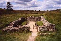
Mithraeum at Carrawburgh. Photo © Northumberland County Council.

Mithraeum at Carrawburgh. Photo by Northumberland County Council.
(Previously recorded by the Ordnance Survey as NY 87 SE 10.3 and 10.7)
NY 85877106. Excavation, in 1950, of the mithraeum at Brocolitia showed three building phases. The earliest belongs to the first quarter of the 3rd century and produced one of the smallest buildings of its type measuring only 18ft 3ins by 26ft externally. A northern extension, started c.AD222, constituted Mithraeum II, which underwent two internal refits before its destruction in AD 297. The third phase was a total reconstruction at the turn of the 3rd and 4th centuries. It survives until c.AD330 when it was finally desecrated. (1)
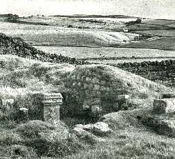
In 1957 a large inscribed altar to the Nymphs and Genius Loci was found standing upright a few yards S of the doorway into the Mithraeum; this was excavated in 1960, and found to be associated with a well, a paved area, and an apsidal structure. Its exact date of construction is unknown, but by the beginning of the 4th century it was in decay. (2)
Scheduled. (3)
The shell of the Mithraeum measures 12.3m N-S by 5.7m E-W with walls standing to a maximum height of 1.0m. Replicas of the internal fittings have been fitted in cast stone. See G.P. AO/65/143/2. The site of the shrine is under the turf; only a fragment of well casing. (in situ) survives above ground. Surveyed at 1:2500. (4)
The Mithraeum has been consolidated and partly reconstructed in its 4th C form; it is under guardianship and open to the public. Of the remains S of the doorway, nothing is visible on the surface except for the top of the N slab of the well-head. The Mithraeum was surveyed at 1:1000 scale as a part of the Carrawburgh Survey; the plan and report are held in the NMR archive. (5)
Scheduled. (6)
Overall summary. (7a)
The site of the Mithraeum since consolidation and reconstrucion was seen and mapped from air photographs. (7b)
Near Carrawburgh fort stands a temple of the god beloved by Roman soldiers, with facsimiles of altars found during excavation. Sited like many Mithraic temples near a military base, it was founded in the 3rd century, and eventually desecrated, probably by Christians. Nearby was the still more popular well shrine of the water-nymph Coventina (7c-d)
Located on the English Heritage map of Hadrian's Wall 2010. (7e)
General association with HER 7879 (Carrawburgh Roman Fort), HER 31737 (Roman inscriptions), HER 7931 (Coventina's Well), HER 7929 (Carrawburgh Vicus). (7)
N7932
EXCAVATION, Carrawburgh (Mithraeum) 1950; Durham Excavation Committee
EXCAVATION, Carrawburgh (Shrine of the Nymphs) 1960
FIELD OBSERVATION (VISUAL ASSESSMENT), Ordnance Survey Archaeology Division Field Investigation 1962; W D Johnston
FIELD OBSERVATION (VISUAL ASSESSMENT), Ordnance Survey Archaeology Division Field Investigation 1966; E C Waight
AERIAL PHOTOGRAPHY, Hadrian's Wall Landscape from Chesters to Greenhead 1999; T GATES
WATCHING BRIEF, B6318 'Military Road', Throckley-Gilsland 2007; Pre-Construct Archaeology
WATCHING BRIEF, Carrawburgh Mithraeum ; Solstice Heritage
MEASURED SURVEY, RCHME: Carrawburgh Survey ; RCHME
MEASURED SURVEY, RCHME: Hadrian's Wall Project ; RCHME
Disclaimer -
Please note that this information has been compiled from a number of different sources. Durham County Council and Northumberland County Council can accept no responsibility for any inaccuracy contained therein. If you wish to use/copy any of the images, please ensure that you read the Copyright information provided.