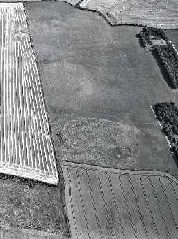
East Moneylaws Camp (Carham)
[NT 88073540] Earthwork. (1)
A near oval earthwork measuring c.120 yds by 60 yds with a very slight appearance of an outer rampart, and an apparent entrance, on the south side. The whole is now ploughed down and little remains. (2)
Listed as a probable pre-Roman multivallate enclosure. (3)
Scheduled. (4)
Generally as described, and in poor condition. There are now no identifiable remains of an entrance on the south side. Resurveyed at 1:2500. (5)
Aerial photographs taken in 2003 show faint traces of the southern ramparts. (6)
The Iron Age fort of Castle Hill is visible as an earthwork and cropmark on air photographs at NT 8807 3540. The innermost rampart appears to be almost complete with a gap in the west. To the north are traces of a second rampart but to the south two more ramparts and three ditches are visible as earthworks and, on later photography, cropmarks. The fort measures 103m by 54m and encloses an area of 0.42ha. Post medieval ridge and furrow overlies the site. (7) (11b)
An irregular oval enclosure about 350ft by 200ft. The defences are largely natural or consist of a scarp with a 4ft rise on the south. (8)
The earthwork measures about 110m by about 50m which retains the slight above-ground remains of the outer rampart. The interior is almost entirely filled with ridge and furrow, or relatively modern origin, which suggests that any internal remains of Iron Age date may survive poorly. (9)
Scheduled. (10)
NT 880 354. East Moneylaws camp. Scheduled No ND/254. (11a)
General association with HER 30236 (ridge and furrow). (11)
N731
FIELD OBSERVATION (VISUAL ASSESSMENT), Ordnance Survey Archaeology Division Field Investigation 1966; E C Waight
AERIAL PHOTOGRAPH INTERPRETATION, English Heritage: Till Tweed NMP 2003; English Heritage
FIELD SURVEY, Hill forts and settlements in Northumberland ; G Jobey
AERIAL PHOTOGRAPH INTERPRETATION, English Heritage: Till Tweed NMP 2003; English Heritage
FIELD SURVEY, Hill forts and settlements in Northumberland ; G Jobey
Disclaimer -
Please note that this information has been compiled from a number of different sources. Durham County Council and Northumberland County Council can accept no responsibility for any inaccuracy contained therein. If you wish to use/copy any of the images, please ensure that you read the Copyright information provided.
