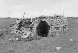
Swinhope Row lime kilns (Allendale)
Two lime kilns. Lime kiln 'A': in good condition; one pot, full of stones; one draw arch, corbelled with lintel, one eye. Lime kiln 'B': fair condition, beginning to fall away; one pot, partially stone-filled; one draw arch, corbelled with lintel, one eye. Both built from drystone and small held kilns. Two large quarries nearby. Kiln 'B' c.300m south west of 'A'. (1)
Swinhope Row lime kiln. Plan, elevation and sectional elevation of a small kiln with one pot and one arch. Scale 1:50. (2)
Approximately 300m north east of kiln B. Two large quarries nearby. The site was seen from a nearby road, as livestock prevented access. A kiln very similar in form and dimensions to kiln A, with a 'bottle-shaped' arch and single round pot. Partly collapsed, but the arch is intact at 2m by 2m. Square in plan, built into slope. No trackway or other earthworks discernible nearby.
Lies approx. 300m south west of kiln A. Two large quarries nearby. A small single-arch field kiln with 'bottle-shaped' arch of 2m x 1.75m, with a single slab forming both roof and lintel of the arch. The interior is corbelled; a single rectangular eye is partly collapsed. The west side of the kiln is entirely collapsed and the round pot (diameter 1.5m) is infilled. Built into a slope, and of drystone construction. (3)
NY83404817. One of the lime kilns is shown on the first edition Ordnance Survey map of 1865. (4)
NY 83370 48200 NRHE UID 958163 Marked as old quarry on 2nd edition mapping.
NY 83680 48260 NRHE UID 958163 Not shown on 2nd edition mapping. (5a)
NY 83680 48260 NRHE UID 958163 Two lime kilns, both having one pot, one arch, corbelled with lintel and one eye. Both were of drystone construction. (5b)
N7096
FIELD SURVEY, Swinhope Row lime kilns 1976; University of Newcastle
THEMATIC SURVEY, North Pennines AONB lime kiln survey 2000; LANCASTER UNIVERSITY ARCHAEOLOGICAL UNIT
FIELD SURVEY, RCHME: North Pennines Industrial Archaeology Project ; RCHME
THEMATIC SURVEY, North Pennines AONB lime kiln survey 2000; LANCASTER UNIVERSITY ARCHAEOLOGICAL UNIT
FIELD SURVEY, RCHME: North Pennines Industrial Archaeology Project ; RCHME
Disclaimer -
Please note that this information has been compiled from a number of different sources. Durham County Council and Northumberland County Council can accept no responsibility for any inaccuracy contained therein. If you wish to use/copy any of the images, please ensure that you read the Copyright information provided.
