Native settlement near Great Hetha (Kirknewton)
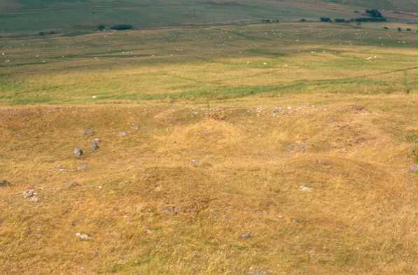
Roman period native settlement near Great Hetha, Kirknewton. Photo by Northumberland County Council.
(NT 88112750) Homestead. (1)
A sub-rectangular enclosure consisting of a series of terraces formed on a fairly steep slope. Faint traces of possible hut floors some 16-20ft in diameter remain on some of the terraces and there is one small but marked scoop above a north facing entrance. (2)
A homestead of Jobey's Romano-British Type as described. Published survey (25 inch) revised. (3)
NT 881275: A scooped settlement at Hetha Burn consisting of nine or ten circular houses set on terraces and in scoops was examined and partially excavated by C Burgess in 1969. The two houses excavated were constructed of stone and contained Romano-British material probably of 1st century date. Excavation of the entrance revealed an entrance passage 5m long and over 2m wide. It was revetted with crude stone walling. A gate stood at its outer end and there was at least one 'horn' at its inner end. A trench was cut across the enclosure bank of the lowest terrace. It was found to be 2m wide and internally stone faced. A possible circular timber house and hearth were uncovered under one of the stone houses suggesting the presence of an earlier settlement. See plan. (4)
Excavations of one of the two settlements on the east bank of Hetha Burn between 1969-72 distinguished three structural phases.
Phase 1 which included a large timber ring-groove house is attributed to the Iron Age.
Phase II comprised a settlement apparently constructed early in the Roman occupation with a rectangular perimeter wall measuring c.30m by 40m. It contained a succession of stone built circular houses.
Phase III. an enclosed 'scooped settlement' was added to the uphill side. This phase has yielded fragments of glass and Romano-British pottery. (5)
NT 880275. Hetha Burn Settlement, Kirknewton. Scheduled. (6)
Additional bibliography. (7)
Hetha Burn 1 is a classic example of a scooped enclosure. First phase timber ring-groove buildings succeeded by eight or more circular stone Romano-British buildings. (8)
Scheduled. (9)
Hetha Burn 1 is visible on a series of aerial photographs. (Description as above). (10)
Roman period native enclosed settlement 370m WNW of Great hetha defended settlement. Earthwork remains of terraces, one above the other, cut into the steep hillside. The terraces contain the remains of platforms and scoops and the remains of circular, stone founded prehistoric houses. To the east, immediately above the terracing, are a number of individual scoops cut into the hillside. The settlement is partly enclosed by stone and earth banks; scheduled. (11a)
A sub-rectangular enclosure consisting of a series of terraces formed on a fairly steep slope. Faint traces of possible hut floors some 16-20ft in diameter remain on some of the terraces and there is one small but marked scoop above a north facing entrance. (2)
A homestead of Jobey's Romano-British Type as described. Published survey (25 inch) revised. (3)
NT 881275: A scooped settlement at Hetha Burn consisting of nine or ten circular houses set on terraces and in scoops was examined and partially excavated by C Burgess in 1969. The two houses excavated were constructed of stone and contained Romano-British material probably of 1st century date. Excavation of the entrance revealed an entrance passage 5m long and over 2m wide. It was revetted with crude stone walling. A gate stood at its outer end and there was at least one 'horn' at its inner end. A trench was cut across the enclosure bank of the lowest terrace. It was found to be 2m wide and internally stone faced. A possible circular timber house and hearth were uncovered under one of the stone houses suggesting the presence of an earlier settlement. See plan. (4)
Excavations of one of the two settlements on the east bank of Hetha Burn between 1969-72 distinguished three structural phases.
Phase 1 which included a large timber ring-groove house is attributed to the Iron Age.
Phase II comprised a settlement apparently constructed early in the Roman occupation with a rectangular perimeter wall measuring c.30m by 40m. It contained a succession of stone built circular houses.
Phase III. an enclosed 'scooped settlement' was added to the uphill side. This phase has yielded fragments of glass and Romano-British pottery. (5)
NT 880275. Hetha Burn Settlement, Kirknewton. Scheduled. (6)
Additional bibliography. (7)
Hetha Burn 1 is a classic example of a scooped enclosure. First phase timber ring-groove buildings succeeded by eight or more circular stone Romano-British buildings. (8)
Scheduled. (9)
Hetha Burn 1 is visible on a series of aerial photographs. (Description as above). (10)
Roman period native enclosed settlement 370m WNW of Great hetha defended settlement. Earthwork remains of terraces, one above the other, cut into the steep hillside. The terraces contain the remains of platforms and scoops and the remains of circular, stone founded prehistoric houses. To the east, immediately above the terracing, are a number of individual scoops cut into the hillside. The settlement is partly enclosed by stone and earth banks; scheduled. (11a)
N610
FIELD SURVEY, Rectilinear earthworks in Northumberland: some Medieval and Later settlements 1960; JOBEY, G
FIELD OBSERVATION (VISUAL ASSESSMENT), Ordnance Survey Archaeology Division Field Investigation 1967; D Smith
GEOPHYSICAL SURVEY, geophysical survey at Hetha Burn 1 1969; Newcastle University
EXCAVATION, Hetha Burn 1973; Newcastle University, colin burgess
FIELD SURVEY, A note on scooped enclosures in Northumberland
HISTORIC AREA ASSESSMENT, Hethpool Village Atlas (HISTORIC BERWICK VILLAGE ATLAS) ; The Archaeological Practice Ltd
FIELD OBSERVATION (VISUAL ASSESSMENT), Ordnance Survey Archaeology Division Field Investigation 1967; D Smith
GEOPHYSICAL SURVEY, geophysical survey at Hetha Burn 1 1969; Newcastle University
EXCAVATION, Hetha Burn 1973; Newcastle University, colin burgess
FIELD SURVEY, A note on scooped enclosures in Northumberland
HISTORIC AREA ASSESSMENT, Hethpool Village Atlas (HISTORIC BERWICK VILLAGE ATLAS) ; The Archaeological Practice Ltd
Disclaimer -
Please note that this information has been compiled from a number of different sources. Durham County Council and Northumberland County Council can accept no responsibility for any inaccuracy contained therein. If you wish to use/copy any of the images, please ensure that you read the Copyright information provided.