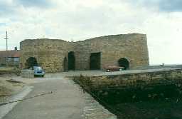
Beadnell Harbour lime kilns (Beadnell)
[NU 23732857] Old lime kilns - Beadnell lime kilns. 18th century, property of National Trust. (1)
Lime kilns to east of Beadnell Harbour. Built in 1798 and later extended by Richard Pringle for John Wood. Three circular kilns c.30ft tall, divided at ground level by tunnel-vaulted passages. Each kiln has three segmental drawing arches decreasing in size inwards. Most southerly kiln has partly collapsed on seaward side. (2)
By 1822 trade at the kiln had declined and the kiln eyes used for curing herring. (3)
Group of preserved 18th century limekilns by the harbour. Used for storage by fishermen. (4)
Limekilns, restored by The National Trust. Exposed to marine erosion, sea and spray. See photographs C12-13 and slides Y29-30. (5)
A well preserved group of three circular commercial lime kilns located at the north end of Beadnell Bay. They consist of one original central kiln of 1798 with two later additions. The kilns, of random coursed sandstone masonry with limited coursing, stand over c.9m high, are divided at ground level by tunnel vaulted passages and have a single circular pot each. Two kilns have three segmental draw arches whilst the north west kiln has an additional arch. Other features include a harbour (NU 22 NW 20) to the south west for the export of lime by sea to Scottish markets and the remains of a charging ramp to the rear. A large quarry, 0.7km to the north west, supplied the limestone. Now used by local fishermen to store lobster pots. (6)
Additional reference (3a)
Three post medieval lime kilns are visible as structures on air photographs, centred at NU 2374 2858. The features are still extant on the latest 1999 Ordnance Survey vertical photography. (3b)
N5790
FIELD OBSERVATION (VISUAL ASSESSMENT), Ordnance Survey Archaeology Division Field Investigation 1955; J H Ostridge
PHOTOGRAPHIC SURVEY, Northumberland Coastal Survey 1992; GUARD
FIELD SURVEY, Northumberland Coastal Survey 1992; GUARD
FIELD OBSERVATION (VISUAL ASSESSMENT), Beadnell Harbour lime kilns 1996; HEDLEY, I
FIELD OBSERVATION (VISUAL ASSESSMENT), Lime Kilns in the Northumberland Coast Area of Outstanding Natural Beauty (AONB) 2010; The Archaeological Practice Ltd
AERIAL PHOTOGRAPH INTERPRETATION, English Heritage: North East Coast NMP Rapid Coastal Zone Assessment Survey ; Archaeological Research Services
Disclaimer -
Please note that this information has been compiled from a number of different sources. Durham County Council and Northumberland County Council can accept no responsibility for any inaccuracy contained therein. If you wish to use/copy any of the images, please ensure that you read the Copyright information provided.
