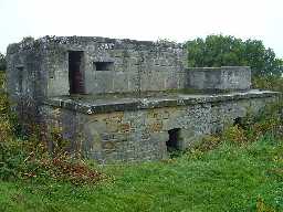
Old Battery (Alnmouth)
Old Battery overlooking Alnmouth Links, grade II listed building. Dated 1881, altered in Second World War. Irregular L-plan, sunk c.1.5m below ground level are a rectangular chamber and small magazine. Above the magazine is a turret remodelled as a pillbox. Inscribed tablet:
'THIS BATTERY WAS ERECTED BY HIS GRACE ALGERNON DUKE OF NORTHUMBERLAND K.G. FOR THE USE OF THE PERCY ARTILLERY VOLUNTEERS COMPLETED 12TH MARCH 1881'. (1)
Coastal pillbox briefly recorded under the name Alnmouth. (2)
Victorian gun battery survives exceptionally well in its original form. There are some late Second World War modifications but the core original structure still survives. Other earthworks also survive and could relate to the original battery or could be Second World War features. (3)
A post medieval/Twentieth Century battery and Second World War military building, trackway and road block are visible as structures on air photographs. The battery appears to have been re-used during the Second World War and is located at NU 2512 1107. The road block is located at NU 2510 1102 and the military building is at NU 2515 1109. The battery and road block appear to be extant on the latest 1999 Ordnance Survey vertical photography, whilst no other surface features are visible. (4a)
N5776
FIELD SURVEY, North East Rapid Coastal Zone Assessment - Phase 2 2010; Archaeological Research Services
AERIAL PHOTOGRAPH INTERPRETATION, English Heritage: North East Coast NMP Rapid Coastal Zone Assessment Survey ; Archaeological Research Services
AERIAL PHOTOGRAPH INTERPRETATION, English Heritage: North East Coast NMP Rapid Coastal Zone Assessment Survey ; Archaeological Research Services
Disclaimer -
Please note that this information has been compiled from a number of different sources. Durham County Council and Northumberland County Council can accept no responsibility for any inaccuracy contained therein. If you wish to use/copy any of the images, please ensure that you read the Copyright information provided.
