St Cuthbert's Chapel (Holy Island)

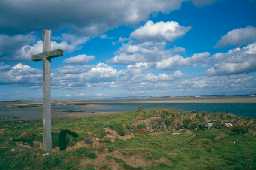
Cross on St Cuthbert's Isle, Holy Island. Photo by Northumberland County Council.

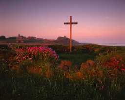
St Cuthbert's Isle, Holy Island (Copyright © Don Brownlow)

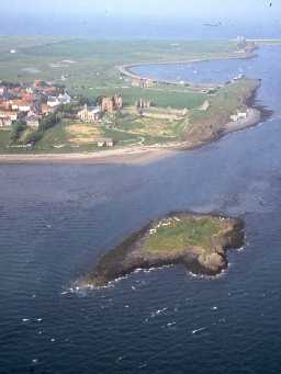
St Cuthbert's Isle from the air, with Holy Island behind. Photo by Mick Aston, 2000.
(NU 12304161) Chapel (Remains of). (1)
The chapel of St Cuthbert is situated on an island completely isolated at high tide. It was in existence before the Dissolution being mentioned in 1533.
The remains, up to two feet high in places, are 24ft long x 13ft wide. There was possibly a small building at the west end, but indications are very uncertain. (2)
Partially excavated by Sir William Crossman in 1888. At the extreme south east corner of the island, laid on solid rock, were foundations of a building which appears to have been a cell or dwelling place of a priest. It consists of a room 15 feet 10 inches wide divided into two compartments, one of which contained a fireplace. (3)
Remains are of rubble masonry with walls 0.6m thick and a maximum height of 0.8m. The foundations of the building in the south east corner of the island are at NU 12324160 and consist of rubble masonry, but are of no recognisable form. (4)
A plaque on the modern wooden cross at the east end of the chapel states 'Here stood the Altar of St Cuthbert 684 AD - 1553 AD'. (5)
Condition unchanged. (6)
The chapel is believed to be that of St Cuthbert-in-the-Sea, mentioned in medieval documents relating to the Priory. The present remains were in use in medieval times but earlier remains may lie underneath. A resistivity survey on the island in 1985 failed to reveal any previously unknown features. (7)
Scheduled. (8)
Additional reference. (9)(12a)
Erosion of the chapel site has revealed two parallel rows of seemingly deliberately placed light coloured boulders, interpreted as a a possible landing area. (10)
The chapel comprises two rooms forming a T-shaped layout with the larger room to the west. The other structure, possibly accommodation or storage, is on the east end of the island and forms a rectangular structure with two (or possibly three) rooms. These structures are directly threatened by coastal erosion which is especially visible at the west end of the chapel where the eastern wall has been partially lost to wave action. Archaeological deposits are clearly visible in the section. Next to the chapel is a stone-lined drain which may be cut into rock on the east side of the island. A subcircular mound north of the chapel may be a spoil heap from 19th and 20th century excavations or even remains of a monastic cell, although seems less likely given the form of the earthwork. (11)
A medieval chapel is visible as a ruined building on air photographs, centred at NU 1231 4160. The feature is still extant on the latest 2003 NMR oblique photography. (12b)
N5338
EXCAVATION, Chapel of St Cuthbert 1888; CROSSMAN, SIR W
FIELD OBSERVATION (VISUAL ASSESSMENT), Ordnance Survey Archaeology Division Field Investigation 1955; E Geary
FIELD OBSERVATION (VISUAL ASSESSMENT), Ordnance Survey Archaeology Division Field Investigation 1964; R D Loader
FIELD OBSERVATION (VISUAL ASSESSMENT), Ordnance Survey Archaeology Division Field Investigation 1968; B H Pritchard
GEOPHYSICAL SURVEY, St Cuthbert's Isle 1985; LEICESTER UNIVERSITY
FIELD SURVEY, North East Rapid Coastal Zone Assessment - Phase 2 2010; Archaeological Research Services
AERIAL PHOTOGRAPH INTERPRETATION, English Heritage: North East Coast NMP Rapid Coastal Zone Assessment Survey ; Archaeological Research Services
Disclaimer -
Please note that this information has been compiled from a number of different sources. Durham County Council and Northumberland County Council can accept no responsibility for any inaccuracy contained therein. If you wish to use/copy any of the images, please ensure that you read the Copyright information provided.