Hope Farmhouse (Brinkburn and Hesleyhurst)
(NU 09700158) Peel. (1)
Pele at Hope. [Quotes OS as authority]. (2)
A fortified farmhouse or bastle existed at Brinkburn Hope. (3)
Hope farmhouse stands west of a block of farmbuildings upon a south-west facing pasture slope. The site commands the valley of the Black Burn to the north-west and south-west and overlooks falling ground to the south and east. Open moors rise to the north-east.
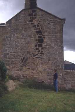
The farmhouse is of modern construction except for the lower courses of stonework of the north-west wall. To a height of approx 4m the stonework is of rough-fashioned stones of various sizes raised upon foundations of large shaped boulders. The wall is 5.9m long and terminates with quoins roughly squared. It is approx 0.6m in thickness.
In the centre is a retaining arch of long flat stone over a blocked-up entrance. There are no other traces of an earlier structure within or around the farmhouse. Mr Heron, the tenant can offer no information about the house. (4)
Condition unchanged. (5)
The bastle was built at the end of the 16th century. Listed by Dodds. (6a-b)
N2936
FIELD OBSERVATION (VISUAL ASSESSMENT), Ordnance Survey Archaeology Division Field Investigation 1957; A S Phillips
FIELD OBSERVATION (VISUAL ASSESSMENT), Ordnance Survey Archaeology Division Field Investigation 1971; B H Pritchard
FIELD OBSERVATION (VISUAL ASSESSMENT), Ordnance Survey Archaeology Division Field Investigation 1971; B H Pritchard
Disclaimer -
Please note that this information has been compiled from a number of different sources. Durham County Council and Northumberland County Council can accept no responsibility for any inaccuracy contained therein. If you wish to use/copy any of the images, please ensure that you read the Copyright information provided.
