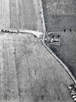
Possible prehistoric settlement NNE of Flodden. (Ford)
(NT 9224 3541) Crop mark of enclosure. (1)
Listed among rectilinear earthworks tentatively classified as Romano-British. (2)
No surface traces, site falls in an arable field. (3)
Crop mark shows three sides of a square/rectangular(?) enclosure. (4)
Three complete sides, and part of the fourth side are visible on aerial photographs taken in 2003. (5)
A single ditched rectilinear enclosure stands on an E-facing slope at 70m OD. Approximately two thirds of the perimeter is visible an air photographs but the SE quadrant is obscured by a road. There is no definite indication of any entrance or of interior occupation. The enclosure measures 50m E-W by 50m N-S and has an internal area of c.0.25ha. (6) (
Scheduled. (7)
NT 922534 Camp 400yds (370m) north-north-east of Flodden; scheduled. (8a)
The site has been mapped from the air as part of the Milfield Geoarchaeology Project. (See archive object MD000293) (8)
N1835
FIELD SURVEY, Rectilinear earthworks in Northumberland: some Medieval and Later settlements 1960; JOBEY, G
FIELD OBSERVATION (VISUAL ASSESSMENT), Ordnance Survey Archaeology Division Field Investigation 1967; R W Emsley
FIELD OBSERVATION (VISUAL ASSESSMENT), Ordnance Survey Archaeology Division Field Investigation 1967; R W Emsley
Disclaimer -
Please note that this information has been compiled from a number of different sources. Durham County Council and Northumberland County Council can accept no responsibility for any inaccuracy contained therein. If you wish to use/copy any of the images, please ensure that you read the Copyright information provided.
