Low Chibburn Preceptory (Widdrington Village)

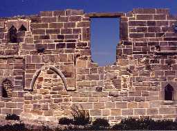
Chapel at Low Chibburn. Photo by Northumberland County Council.

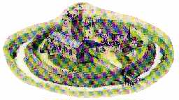
Artist's impression of how Low Chibburn may have appeared in the 1400s. Drawn by Terry Ball.

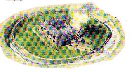
Artist's impression of how Low Chibburn may have appeared in 1691. Drawn by Terry Ball.
Chapel (Ruins of). Moat (Site of). (1)
The remains of this Chapel still exist as shown on O.S. The north wall is fragmentary, although the remaining section adjoining the east wall, is 6ft high. The east wall is in fairly good condition, it stands approximately 15ft high and retains the window frame. The south wall is in the best condition, it stands approx 15ft high and two doorways and a window are blocked; although one window frame remains. The eastern end of this chapel has been fortified and used as a blockhouse during the recent war. (2)
[Name centred NZ 26679650] Low Chibburn. (3)
Knights Hospitallers at Chibburn. (Existed until AD 1500). (4)
Knights Hospitallers founded at Chibburn pre AD1313 and dissolved pre AD1535(?) Net income in 1535 was £43.
First recorded AD1313. (Plan showing complete buildings of a house of this order).(a) In 1338 the community consisted of three brethren including the preceptor and a chaplain brother, a chaplain, a clerk, two officials and three servants. (b)
In an account of 1338 we learn that the gross income amounted to £23-18-8 and the manor house was ruinous. The possessions were surrendered in 1540. The establishment was possibly founded by the Fitzwilliams or by the Widdringtons, who held under them in 12th century.
The Preceptory of the Knights of St John was defended by a moat enclosing an area c.100 yards diameter; the buildings formed a parallelogram having a courtyard in the middle, a dwelling house on the west, a chapel occupying the entire south side and various offices on the north and east sides - the principal entrance was by an arched gateway on north side. The dwelling house is of two stories with three compartments on each floor. A piscina remains in south-east angle of the chapel; human bones have been found and a grave slab forms the threshold of the door leading from courtyard into a stable. The upper portion of a stone coffin is in one of the windows.
The present dwelling house was erected after the Dissolution possibly by Sir John Widdrington, who was granted the manor of Chibburn in 1153.(c) The preceptory of Chibburn. (5)
Scheduled Ancient Monument. (6)
[NZ 26589653] The descriptions in T2 and T5 and the plan in the latter are, generally, correct, except that the majority of the buildings in the northern range have now disappeared. (For extant remains see plan at end of this entry).
The walls of the western range and what little remains of the northern range are of rough dressed masonry with rubble filling. This part of the building represents the remains of the 16th century Manor House mentioned in T5.
The walls of the chapel are of much finer workmanship, and represent the sole remains of the Preceptory of the Knights of St John. The position of the piscina is as stated in T5. The grave slab and the upper portion of stone coffin mentioned in T5 were not seen. The remains are in a ruinous condition and the whole building is now roofless. No trace of the moat remains and the OS siting has been accepted. Open-cast mining is taking place in the near vicinity.
F/54/13/5 Chapel and Manor House looking west; F/54/13/6 Chapel and Manor House looking north; F/54/13/7 Manor House looking east. (7)
The ruins now fall in the centre of an active open-cast mining site, but they have been fenced off and their condition is substantially unchanged. (8)
The surrounding land has been restored to pasture. A rectified photographic survey has taken place and is lodged with SMR. A World War II pill box has been incorporated into the east end of the chapel. Records from the Opencast Executive indicate that the south and east sides of the moat were never excavated, therefore the moat may still survive under imported soil. (9)
Earliest reference to a Hospitaller property (a 'Commandery') at Chibburn is in 1313. The chapel and W range remained in fair condition until 19th century. Major repairs carried out in 1894. West range inhabited until c.1940; the east end of the chapel was converted to a pillbox about this time. Serious deterioration 1954-1970's. (10)
First mentioned 1313. One of the few houses the Knights Hospitallers had in the region. They were founded in 1092, with the building of a hospital at Jerusalem. Built their first house in England in 1100, over 53 lesser houses followed. (11)
Scheduling revised. (12)
A programme of consolidation and repair has been carried out in 1995-6 by Northumberland County Council. The work has included: unblocking door and window openings, piles of loose stone have been removed from the interior, structural repairs and fireplace jambs and timber lintels reinstated. Some of the fallen masonry has been reinstated, including door and window heads. The work was monitored by P Ryder and a programme of architectural and building recording was carried out. (13)(14)(15)
(NZ 2660 9653) Chapel (NR) (rems of) (NAT)
Low Chibburn (NR) (rems of) (NAT) (16a)
NZ 266 965. The Preceptory, Low Chibburn. Scheduled No ND/98. (16b)
A medieval/post medieval hospitallers preceptory, moat and potential pond are visible as earthworks and ruined buildings on air photographs. The preceptory is located at NZ 2659 9653. The section of moat is located to the south-west of the chapel at NZ 2654 9648 and appears to have been reused as a drain in the Twentieth Century. The potential pond is at NZ 2654 9652. The ruined building is still extant on the latest 1989-1998 Ordnance Survey vertical photography. The earthwork moat and fishpond have been destroyed due to open cast mining (UID 14468219). (16d)
Additional reference (16c)
General association with HER 31989 and HER 31990. (16)
Additional reference. (17)
N11884
Post Medieval (1540 to 1901)
20th Century (1901 to 2000)
Second World War (1939 to 1945)
Medieval (1066 to 1540)
20th Century (1901 to 2000)
Second World War (1939 to 1945)
Medieval (1066 to 1540)
FIELD OBSERVATION (VISUAL ASSESSMENT), Ordnance Survey Archaeology Division Field Investigation 1954; E Geary
ARCHITECTURAL SURVEY, Architectural Fragments from Low Chibburn 1994; P RYDER
BUILDING SURVEY, Some Architectural Features at Low Chibburn, Northumberland 1995; P Ryder
WATCHING BRIEF, duplicate of Event 13117 1996; P RYDER
ARCHITECTURAL SURVEY, Investigation by RCHME/EH Architectural Survey ; RCHME
ARCHITECTURAL SURVEY, Architectural Survey of Low Chibburn preceptory
AERIAL PHOTOGRAPH INTERPRETATION, English Heritage: North East Coast NMP Rapid Coastal Zone Assessment Survey ; Archaeological Research Services
Disclaimer -
Please note that this information has been compiled from a number of different sources. Durham County Council and Northumberland County Council can accept no responsibility for any inaccuracy contained therein. If you wish to use/copy any of the images, please ensure that you read the Copyright information provided.