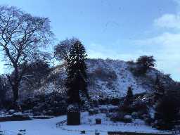
Haw Hill (Morpeth)
(NZ 19988564) The original Morpeth Castle was taken by William II in 1095 and is also referred to in 1138. It stood on the triangular hill (Ha' Hill) (Haw Hill - OS 6 inch 1950) between the River Wansbeck and the spur (which may have formed its bailey) upon which the later (14th century (2)) castle was built. Excavation of the old castle site in 1830 revealed scalloped capitals and billet mouldings. (1)(2)
Published survey (25 inch) revised. Earthwork remains only. (3)
Ha Hill. Stones of Norman workmanship were found on Ha Hill when scraping. Suggest tower or castle on the site. (4)
The mound is partly natural and partly artificial. Probably the site of the first Morpeth Castle - a motte and bailey built of wood by William de Merlay who, in 1080, was granted the barony of Morpeth from the Tyne to Coquet. Ha' Hill probably had a timber stockade enclosing a timber house. Ha' Hill castle appears to have been replaced in the 12th century by a stone castle on a stronger site to the south (NZ 28 NW 1). The summit of the hill was excavated in 1830 by William Woodman; he found several curious stones, rudely carved. On the east side of the hill the foundations were taken up of a long, narrow building, possibly (considered Woodman) a chapel dedicated to St Michael. (5)
One of two castles in Morpeth. (6)
High or Ha' Hill is at the extreme point of the ridge between the Wansbeck and the brook running on the north side of the castle. Hodgson records Woodman's discoveries in 1830. (7)
Scheduled (8)
Topographic survey and historical research were carried out at Haw Hill in 1999, ahead of landscaping work in Carlisle Park. A digital terrain model has also been prepared. Documentary evidence suggests that it was the site of an early Norman fortification which may have continued in use until 1216. Survey revealed an artificial platform on top of the motte which would have served as the foundation of a keep. A smaller hill to the south west has been interpreted as the site of a bailey; however, the morphology of the monument does not support this. A more likely location for a bailey, if there was one, is on level ground to the east, and now developed. (9)(10)
The overall shape and form of this monument is visible on on air photos and lidar imagery. (11)
Listed by Cathcart King and Dodds. (12a-b)
N11068
EXCAVATION, Excavation at Morpeth Castle 1830; WOODMAN, W
FIELD OBSERVATION (VISUAL ASSESSMENT), Ordnance Survey Archaeology Division Field Investigation 1971; B H Pritchard
PHOTOGRAPHIC SURVEY, Haw Hill, Carlisle Park 1999; LANCASTER UNIVERSITY ARCHAEOLOGICAL UNIT
MEASURED SURVEY, Haw Hill, Carlisle Park 1999; LANCASTER UNIVERSITY ARCHAEOLOGICAL UNIT
FIELD OBSERVATION (VISUAL ASSESSMENT), Ordnance Survey Archaeology Division Field Investigation 1971; B H Pritchard
PHOTOGRAPHIC SURVEY, Haw Hill, Carlisle Park 1999; LANCASTER UNIVERSITY ARCHAEOLOGICAL UNIT
MEASURED SURVEY, Haw Hill, Carlisle Park 1999; LANCASTER UNIVERSITY ARCHAEOLOGICAL UNIT
Disclaimer -
Please note that this information has been compiled from a number of different sources. Durham County Council and Northumberland County Council can accept no responsibility for any inaccuracy contained therein. If you wish to use/copy any of the images, please ensure that you read the Copyright information provided.
