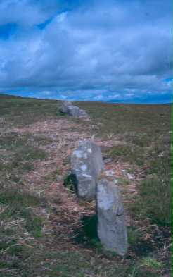
Iron Age or Roman field system (Brinkburn and Hesleyhurst)
At the north end of the hill (Garleigh Hill) there is an irregular line, about 40 yards long, of 21 upended or recumbent stones (seven stones shown on OS 6 inch at NZ 06139932). None stands higher than 2ft, or is more than 4ft long and they are not close enough together to constitute a wall. A second line standing closer together occurs between Garleigh and Lordenshaws (five stones shown on OS 6 inch at NZ 05859915). Probably the remains of ancient field boundaries. (Greenwell noted three lines in 1877). (2)(1)
The instances of developed field systems which can be seen to be associated with Romano-British settlements remain exceptional. In many cases they are demonstrably later. Perhaps less equivocal are the remains of intermittent enclosure walls close to the settlement which overlies the hillfort at Lordenshaws (NZ 09 NE 2), but final proof of their context is lacking. (3)
The two lines of stones (no trace of the third) are clearly field boundaries and they comprise the tangible evidence for early cultivation near the fort at Lordenshaws. Stone clearance has obviously taken place in the vicinity of the walls and in the area centred NZ 057991, but only three 'cairns' are involved (see NZ 09 NE 8). Towards the south and again in the area centred NZ 056995, where there is a further fragment of walling and four cairns (NZ 09 NE 6), innumerable small heather-covered outcrops give the impression of 'clearance heaps'. Some of these outcrops appear to have been used as corner 'markers' for fields and there is some evidence of lynchetting, but no coherent pattern can be envisaged and the whole is confused by the intrusion of later field boundaries and tracks. (4)
Scheduled. (5)
NZ 053 992 etc. Cup and ring marked rocks, stone rows, tumuli, cairns and Garleigh Hill stone circles and Lordenshaw camp, Hesleyhurst. Scheduled No ND/86. (6a)
The south end of the line of stones centred at NZ 056 995 lies within the area surveyed by RCHME in December 1990. (6b)
N10743
Disclaimer -
Please note that this information has been compiled from a number of different sources. Durham County Council and Northumberland County Council can accept no responsibility for any inaccuracy contained therein. If you wish to use/copy any of the images, please ensure that you read the Copyright information provided.
