Hartburn unenclosed settlement (Hartburn)
A Roman fortlet on the south side of the Hart Burn on high ground 1500 feet west of the road (Devil's Causeway). The defences, two widely spaced ditches and a rampart, are visible in drought both from the air and on the ground. A centrally placed single gate on the south side gives access to an internal area of about 150 square feet. (1)
(NZ 08158661) Visible on aerial photographs as a crop mark. (2)
The work falls in two arable fields, and the west side only is traceable on the ground as a superficial depression-cum-berm. The irregularity of the ditches (as shown on the photographs) suggests a non-military, and therefore probably non-Roman work; and it might rather be 'native' or even medieval. (3)
Additional reference (4)
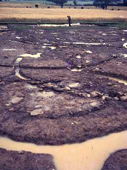
A rescue excavation undertaken by DOE proved this site to be a native settlement and not a Roman fortlet. The whole of the interior was stripped which revealed evidence of at least 36 round houses, but not all existing at one and the same time. Earliest occupation could be late Bronze Age/early Iron Age, whilst the latest is more assuredly Roman. It looks very much as if a Roman native settlement had been established on the site of an earlier Iron Age defensive work. There was no evidence of a palisaded perimeter. (5)
Iron Age/Romano-British settlement. (6)
NZ 082866. Hartburn possible unenclosed settlement. (7)
Rectilinear ditched enclosure with irregular outer ditch and almost square inner ditch. 36 timber round houses discovered, relationship with enclosure ditches uncertain. Ceramic evidence dates occupation from 5th/6th century BC - 2nd century BC. Twelve phases of timber buildings recognised. (8)
NZ 081867. Rescue excavation on twin-ditched enclosure at Hartburn, previously recorded as a Roman fortlet, shows it was a native settlement possibly 6th or 5th century BC. Complex of house replacements suggest near continuous occupation until final phase, represented by a Romano-British settlement of standard pattern in the area [NZ 08 NE 13].
Site first discovered from the air by J K St Joseph. Two small cuttings made by Sir Walter Aitchison in 1949, over the inner ditch; only established its width and depth. [Full excavation report]. (9)
Probable progression from a large unenclosed pre-Roman Iron Age settlement to a small rectilinear Roman homestead. Roman occupation, possibly short-lived or seasonal, indicated by the dearth of Roman material present. Faunal assemblage included cattle, sheep/goat and horse.
Radiocarbon dating of twigs in a hearth 150BC-AD305 (I-6301); and of twigs from inner ditch 450BC-AD370 (I-6300). (10)
A stone with a 'bar mould' [may be from this site], of Iron Age date, was given by G Jobey to the Museum of Antiquities, Newcastle, accession number 1975.7. (11)
Visible on GoogleEarth aerial photograph. (12)
Descheduled. (13a)
N10449
EXCAVATION, Aitchison excavations - A Native Settlement at Hartburn and The Devil's Causeway, Northumberland (1971) 1949
FIELD SURVEY, Hartburn enclosed settlement 1960; JOBEY, G
FIELD OBSERVATION (VISUAL ASSESSMENT), Ordnance Survey Archaeology Division Field Investigation 1968; R W Emsley
EXCAVATION, A Native Settlement at Hartburn and The Devil's Causeway, Northumberland (1971) 1972
FIELD SURVEY, Hartburn enclosed settlement 1960; JOBEY, G
FIELD OBSERVATION (VISUAL ASSESSMENT), Ordnance Survey Archaeology Division Field Investigation 1968; R W Emsley
EXCAVATION, A Native Settlement at Hartburn and The Devil's Causeway, Northumberland (1971) 1972
Disclaimer -
Please note that this information has been compiled from a number of different sources. Durham County Council and Northumberland County Council can accept no responsibility for any inaccuracy contained therein. If you wish to use/copy any of the images, please ensure that you read the Copyright information provided.
