Belsay Park (Belsay)

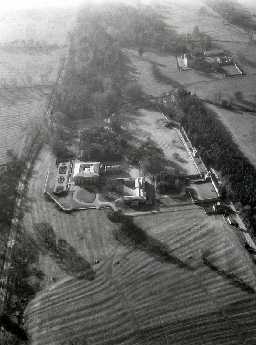
View over Belsay Hall showing grounds. Photo © Tim Gates.

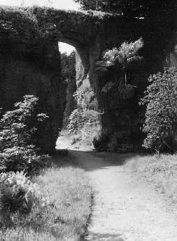
Belsay Quarry Garden. Photo Northumberland County Council, 1956.
These are the remains of the parkland and gardens surrounding Belsay Hall. The garden terraces and walled areas (about 1.3 ha) are situated in a larger picturesque landscaped grounds (about 12ha). These, in turn, are placed within a larger (275ha) park. This deer park was extended in the 17th century, with the planting of belts of woodland. It was further landscaped in the later 18th century, by Sir William Middleton. The gardens and grounds were created about 1810-20 and extended in the later 19th century. These works on the gardens swept away many earlier features, such as the formal gardens shown on an engraving of 1728. (1-7)
The most radical phase of landscaping at Belsay took place in the mid 18th century destroying or obscuring much of the former environs of the castle. An engraving of 1728 shows a formal garden south of Belsay Castle, but a large area was emparked in a less formal way with tree planting, the creation of a wild garden, ha-has and carriage drives.This landscaping took on a new impetus at the time of Sir Charles Monck when Belsay was built (1810-17). Formal gardens were created around the Hall, and also, in a novel way, the linear quarries west of the house were modified to make a sunken garden. The total area of parkland was about 130 hectares or more, of which RCHME surveyed some 70 hectares at 1:1000 scale. The original plan and a detailed report on the development of the park and gardens is held in the NMR archive. The greater part of the gardens is in the care of English Heritage and open to the public. (8a)
Deer park, planted and extended during the 17th century, and landscaped during the mid-late 18th century by Sir William Middleton. This landscaping destroyed much of the earlier landscaping an engraving of 1728 shows an area of formal gardens and Wild Gardens. The garden terraces, gardens and further extensions to the park were carried out circa 1810-20 by Charles Monck. The park was further extended during the later 19th century by Sir Arthur Middleton. The house is situated on an artificial terrace surrounded by a ha-ha. The terraced lawn slopes to a late 19th century parterre. Other late 19th century features include a winter garden which is set around a sunken lawn, the Quarry garden, lawns, glades and massed rhododendron planting. The park is mainly of open parkland in the east with perimeter belts and clumps. Features include a lake with a bridge and waterfall laid out circa 1810-20, and an avenue. The castle is set in terraced lawns and 19th century formal beds, with wooded grounds to the west. (8b)
The park was landscaped during the early 17th century, when alterations were made to Belsay Castle. The landscaping involved tree planting and the creation of formal gardens around the castle which are shown in an engraving of 1728. Later 18th century changes to the park took place between 1769-95 and were made by Sir William Middleton. Construction of Belsay Hall started in 1807 and moved the focus of the park away from Belsay Castle, and involved the removal of the nearby village and chapel. Sir Charles Monck created formal gardens around the hall and the planting of Quarry Garden, a quarry which supplied building material for the hall, as a Romantic Garden. Formal gardens around the castle were removed. Between 1867 to 1933 Sir Arthur Middleton extended the gardens and planted less formalised schemes. Between 1903 to 1914 he established rhododendron collections. New planting schemes were also introduced in the Quarry Garden. Some replanting of the gardens took place following World War II, and the gardens were opened during the 1950s. A programme of restoration of the park and gardens took place between 1982-84. (8c)
NMR aerial photography.(8d-f)
Landscape park covering an area of 275 hectares. Landscaping first took place from 1717 by Sir William Middleton who created an ornamental parkland landscape and formal gardens. The formal gardens are visible as earthworks. The park was extended circa 1790. Major changes to the grounds were made by Sir Charles Monck from 1806 until his death in 1867. He was inspired by Humphry Repton's designs and principals and resulted in the creation of a picturesque landscape. Further additions to the gardens were made from 1867 by Sir Arthur Middleton. A programme of restoration has taken place since 1985. (8g)
Country Life article on the development of the gardens at Belsay Hall from 1867-1933, including a number of colour illustrations and a plan of the gardens. Illustrations include the "Romantic Quarry" croquet lawns, borders, and the Winter Garden. (8h)
Belsay Park was maped from aerial photographs and lidar in 2017. Several features relating to the park were identified as earthworks. These included the remains of a walled garden (at NZ 0828 7839), Lady Anne Middleton's Garden (at NZ 0837 7878),ha has, boundary banks and roads. Other features which pre-or post-dated the establishment of the park are recorded separately. (8i)
General association with HER 10234 (Belsay Castle), HER 28139 (WW2 trenches), HER 28138 (WW2 trench), HER 34226 (quarrying), HER 34237 (roads), HER 34240 (boundary bank); is referred to by HER 28140 (military buildings). (8)
Additional reference. (9)
N10253
Post Medieval (1540 to 1901)
20th Century (1901 to 2000)
20th Century (1901 to 2000)
TEST PIT, LAND AT BELSAY HALL 2013; Archaeological Services Durham University
GEOPHYSICAL SURVEY, Belsay Hall and Castle 2016; Historic England
AERIAL PHOTOGRAPH INTERPRETATION, Belsay Awakes: Historic England Contribution 2017; Historic England
DESK BASED ASSESSMENT, Belsay Hall Paddock 2019; Archaeological Services Durham University
WALKOVER SURVEY, Belsay Hall Paddock 2019; Archaeological Services Durham University
MEASURED SURVEY, RCHME: Belsay Survey ; RCHME
POST EXCAVATION ASSESSMENT, Land at Belsay Hall ; Archaeological Services Durham University
POST EXCAVATION ASSESSMENT, Belsay Hall ; Archaeological Services Durham University
BUILDING FABRIC ANALYSIS, The Building Stones of England: Northumberland ; Historic England
MANAGEMENT SURVEY, Belsay Hall and Estate ; Historic England
Disclaimer -
Please note that this information has been compiled from a number of different sources. Durham County Council and Northumberland County Council can accept no responsibility for any inaccuracy contained therein. If you wish to use/copy any of the images, please ensure that you read the Copyright information provided.